|
||

|

|
|

|
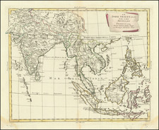
A New Plan of the Straits, situated to the east of Java and Madura, is a detailed representation of the Straits of Bali, constructed from the observations and remarks of various English and French ships during the mid-18th century. Originally conceived by the esteemed Daprès de Mannevillette, this map adeptly delineates the Straits of Bali, Pondi, and Respondi. It draws upon data from the voyages of renowned English ships, including the Winchelsea and the Royal George, as well as the French vessels Elephant and le Chameau. Published by Laurie & Whittle of Fleet Street, London, in 1794, the map is further enriched by an inset of the Bay of Ballambouang, based on a survey conducted aboard the Royal George in 1766.
The latter half of the 18th century witnessed the Southeast Asian maritime routes garnering paramount importance for European trade and colonial objectives. Serving as a pivotal conduit to the archipelagic treasures of the East Indies, the Straits of Bali became a frequent pathway for both English and French maritime expeditions. These voyages not only propelled global commerce but also spurred the growth and refinement of cartography.
Mannevillette's portrayal of the Straits of Bali exemplifies the precision and sophistication inherent in 18th-century European cartography. By integrating observations from various naval sources, the map offers a comprehensive visualization of the region's diverse coastal topography. The map's emphasis on depth soundings and intricate details is indicative of its navigational significance for contemporary sailors.
Essentially, A New Plan of the Straits is an emblem of the Enlightenment era's commitment to collaborative navigation and cartography. It encapsulates the collective maritime expertise of its time, evoking the strategic importance of the Southeast Asian sea routes and the era's scientific accuracy. This map, with its thorough detailing and extensive coverage, offers a compelling window into the perceptions and cartographic endeavors of the 18th century.
Robert Laurie (ca. 1755-1836) and James Whittle (1757-1818) formed their Fleet Street, London-based firm upon the 1794 death of their employer Robert Sayer, himself one of the dominant print and mapmakers of the last half of the 18th century.
Laurie & Whittle started managing Sayer's business as early as 1787. They took over all managerial duties when Sayer's health flagged in 1792, and they changed the imprint in 1794 upon his death. Sayer left the two a 21-year lease on the shop (at £100 a year) and on Sayer's Bolt Court premises, as well as an option to acquire stock and equipment at a preferential price of £5,000 payable over three years.
Robert Laurie retired from the firm in 1812, and his role was assumed by his son, Richard Holmes Laurie (1777-1858). The younger Laurie worked with James Whittle until the latter died in 1818. After R. H. Laurie died in 1858, Alexander George Findlay, FRGS (1812-1875) purchased the firm from his daughters. The firm continues today under another name, specializing in yachting charts.
Laurie & Whittle were prolific print and map publishers, and throughout their careers, they produced numerous very important and rare works. They carried on Robert Sayer's atlas business and were responsible for editions of The Complete East-India Pilot and The American Atlas.

![(First state!) [ Southeast Asia ] Tabula Asiae XI](https://storage.googleapis.com/raremaps/img/small/94616.jpg)