


|
||

|

|
|

|
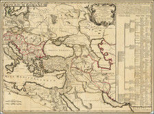
Crafted with extraordinary precision, Brue's map provides a unique insight into the geographical understanding of the Middle East and its surrounding regions during the early 19th century. Dated 1822, this map is an elaborate depiction of territories that have been at the crossroads of civilization and human history.
Spanning across Asia Minor, the Persian Empire, Afghanistan, Balochistan, and a portion of present-day Pakistan, the map encapsulates a historical perspective of regions that had already seen thousands of years of human activity by the 19th century. The ornate cartographic presentation, marked with beautiful calligraphy and intricately detailed coastlines, bears the aesthetic hallmark of European map-making of the era.
In Asia Minor, the early 19th century marked the waning power of the Ottoman Empire. While it still held its territories in the Middle East, North Africa, and Southeast Europe, it faced internal issues and uprisings, such as the Greek War of Independence starting in 1821. This was a period of political transition known as the Tanzimat era, beginning in 1839, where significant administrative, legal, and social reforms were attempted to modernize and consolidate the empire.
The Persian Empire during this time was under the Qajar dynasty. The first half of the 19th century saw two Russo-Persian Wars, in 1804-1813 and 1826-1828, both of which resulted in significant territorial losses for Persia. These losses sparked a period of reform, such as the attempts made by Abbas Mirza, the Crown Prince, to modernize the Persian military.
In "Caboul," the early 19th century was characterized by the First Anglo-Afghan War in 1839. This conflict marked the beginning of British involvement in Afghanistan, with the empire seeking to establish a friendly, compliant Afghan regime to buffer against Russian encroachment into British India.
"Turkestan Independant" experienced dramatic changes in the first half of the 19th century. The region was characterized by decentralized Khanates. However, the expansionist policies of the Russian Empire were already taking shape, with the conquest of the Kazakh Steppe beginning in the early 19th century, setting the stage for greater Russian control over Central Asia in the latter half of the century.
In "Belouchistan," the early 19th century marked a time of considerable autonomy. The Khanate of Kalat, a princely state in what is now Balochistan, held sway. However, the first signs of British interest in the region began to emerge, largely due to its strategic significance to the British Raj in India.
"L'Arabie," or the Arabian Peninsula, was largely under Ottoman control during this time. The Hejaz region, including the holy cities of Mecca and Medina, was an Ottoman province. However, the interior of the Arabian Peninsula remained elusive, populated by nomadic tribes with complex allegiances. Oman was an independent entity, with its influence extending across the Strait of Hormuz and along the East African coast. Yemen, while nominally under Ottoman control, had a great deal of internal autonomy, with its highland regions controlled by the Zaidi Imams. The emirates that would eventually form the UAE were known as the Trucial States, entering into a Perpetual Maritime Truce with the British in 1835, reflecting the region's strategic maritime significance.
Andre Hubert Brué was a French geographer and cartographer. Born in Paris, he served in the French Navy, joining the Baudin expedition to the Pacific (1800-1804). After his sea service, Brué applied his navigation and charting skills to creating finely-crafted maps, which were renowned for their crisp engraving and accuracy. He drew directly on the copper of the plate, creating what he called encyprotypes. He is best known for the Atlas universal de géographie physique, politique, ancienne et moderne.
![Carte de la Grece Dressee sur un grand nombre de memoires anciens et nouveaux, Sur ceux de Mrs. Whele et Tournefort . . . 1745 [includes Cyprus]](https://storage.googleapis.com/raremaps/img/small/94008.jpg)
![[Constantinople, Serrail, Hagia Sophia] Etat Abrege de la Maison du Grand Seigneur . . .](https://storage.googleapis.com/raremaps/img/small/64525.jpg)
![L. Rouwolfs Reys-Togten, door de Levant, of Oosterse Landschappen der Middellandse Zee [shows Cyprus]](https://storage.googleapis.com/raremaps/img/small/83622.jpg)