


|
||

|

|
|

|
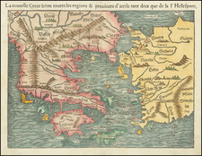
The map "OPAKH. Thraciae Veteris Typus" is a fine representation of Abraham Ortelius's work, illustrating the geography of ancient Thrace. Spanning from Byzantium, modern-day Istanbul, across the Bosphorus Straits to Macedonia, the map offers a detailed view of a region steeped in history.
This map was created based on Gastaldi's 1560 map of South East Europe and information from several ancient sources. The noted sources include reputable figures such as Herodotus, Plinius, Strabo, Appianus, Virgilius, Plutarchus, and Sidonius. Their diverse inputs paint a comprehensive image of the topographical and political landscape of ancient Thrace.
The representation of the region's natural features is one of the highlights of the map. Portions of the Black Sea, Sea of Marmara, and Thrakikon Pelagos are distinctly marked. The stipple engraving technique used to represent these bodies of water gives a textural quality to the map, adding a sense of depth and realism. In addition to the stippling, the areas are fully colored, enhancing their visual appeal and making them standout features of the map.
Ancient Thrace
Thrace, a historical and geographic region in Southeast Europe, holds a unique position in the annals of history due to its geographical location and cultural influences. This region, now a part of modern-day Turkey, Greece, and Bulgaria, has long served as a bridge between Europe and Asia, its terrain encompassing both continental and maritime characteristics.
The ancient Thracians, who inhabited the region from about 1000 BC, were renowned for their warrior culture, metalwork, and horse breeding. Known in Greek mythology as the homeland of the hero Orpheus, Thrace played a prominent role in classical literature and history. Throughout its history, Thrace has been the stage for numerous conflicts due to its strategic location at the crossroads of several important land and sea routes.
Thrace was first brought under Persian control in the late 6th century BC before it was taken over by Alexander the Great's Macedonian empire in the late 4th century BC. This conquest set the stage for a period of Hellenistic influence, as Thrace was Hellenized culturally, politically, and linguistically.
In 46 AD, Thrace was annexed by the Roman Empire and became a province. Roman rule led to urban development and the propagation of Roman culture and law throughout the region. This marked a period of stability and prosperity, which persisted until the decline of the Western Roman Empire.
In the medieval period, Thrace fell under the rule of the Byzantine Empire, which brought Orthodox Christianity and further influenced the local culture. Following the fall of Constantinople in 1453, Thrace entered into Ottoman control, where it remained until the late 19th and early 20th centuries.
In modern times, the territory of ancient Thrace has been divided among Greece, Turkey, and Bulgaria. Despite these divisions, the region retains a rich and shared history marked by cultural exchanges, external influences, and an ever-changing political landscape.
Abraham Ortelius is perhaps the best known and most frequently collected of all sixteenth-century mapmakers. Ortelius started his career as a map colorist. In 1547 he entered the Antwerp guild of St Luke as afsetter van Karten. His early career was as a business man, and most of his journeys before 1560, were for commercial purposes. In 1560, while traveling with Gerard Mercator to Trier, Lorraine, and Poitiers, he seems to have been attracted, largely by Mercator’s influence, towards a career as a scientific geographer. From that point forward, he devoted himself to the compilation of his Theatrum Orbis Terrarum (Theatre of the World), which would become the first modern atlas.
In 1564 he completed his “mappemonde", an eight-sheet map of the world. The only extant copy of this great map is in the library of the University of Basel. Ortelius also published a map of Egypt in 1565, a plan of Brittenburg Castle on the coast of the Netherlands, and a map of Asia, prior to 1570.
On May 20, 1570, Ortelius’ Theatrum Orbis Terrarum first appeared in an edition of 70 maps. By the time of his death in 1598, a total of 25 editions were published including editions in Latin, Italian, German, French, and Dutch. Later editions would also be issued in Spanish and English by Ortelius’ successors, Vrients and Plantin, the former adding a number of maps to the atlas, the final edition of which was issued in 1612. Most of the maps in Ortelius' Theatrum were drawn from the works of a number of other mapmakers from around the world; a list of 87 authors is given by Ortelius himself
In 1573, Ortelius published seventeen supplementary maps under the title of Additamentum Theatri Orbis Terrarum. In 1575 he was appointed geographer to the king of Spain, Philip II, on the recommendation of Arias Montanus, who vouched for his orthodoxy (his family, as early as 1535, had fallen under suspicion of Protestantism). In 1578 he laid the basis of a critical treatment of ancient geography with his Synonymia geographica (issued by the Plantin press at Antwerp and republished as Thesaurus geographicus in 1596). In 1584 he issued his Nomenclator Ptolemaicus, a Parergon (a series of maps illustrating ancient history, sacred and secular). Late in life, he also aided Welser in his edition of the Peutinger Table (1598).
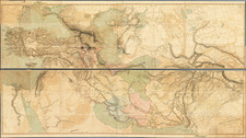
![Turkey in Asia [Including Cyprus]](https://storage.googleapis.com/raremaps/img/small/98704.jpg)
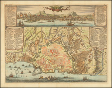
![[ Crete ] Die Insel und das Koenigreich Kandien Nr. 19](https://storage.googleapis.com/raremaps/img/small/101973.jpg)
![[ Aegean Sea ]](https://storage.googleapis.com/raremaps/img/small/96557.jpg)