|
||

|

|
|

|
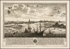
"Prospectus Elegantiores Splendidissimae Archiepiscopalis Urbis Salisburgensis..." by Johann Baptist Homann is a fine set of 11 views featuring the city of Salzburg and significant edifices within and surrounding the city. Published in Nuremberg circa 1720, these illustrations offer a unique glimpse into the architectural grandeur of Salzburg during the Baroque period.
Johann Baptist Homann, the mapmaker, was a renowned German cartographer of the 18th century. His works are notable for their precision, detail, and the integration of landscape views. The views of Salzburg that he presents in this set are no exception, showcasing his attention to architectural details and his talent for capturing the urban environment.
The depicted city, Salzburg, was an important ecclesiastical principality in the Holy Roman Empire during the time these views were created. The buildings captured in the views reflect the city's religious and political significance, ranging from grand cathedrals to princely residences. The architecture of these buildings is predominantly Baroque, a style characterized by dramatic expressions of power, vitality, and glory that aligns with the Counter-Reformation ethos of the period.
In the wider context of Homann's work and the evolution of city views in cartography, this set of views stands out. The integration of cityscapes into cartographic products was becoming increasingly popular during the 18th century, serving not only as visual records of urban development but also as statements of civic pride. Homann's views of Salzburg, with their detailed renderings of architectural landmarks, fit neatly into this trend.
Johann Baptist Homann (1663-1724) was a mapmaker who founded the famous Homann Heirs publishing company. He lived his entire life in Bavaria, particularly in Nuremberg. Initially, Johann trained to become a priest before converting to Protestantism and working as a notary.
In 1702, Johann founded a publishing house that specialized in engravings. The firm flourished, becoming the leading map publisher in Germany and an important entity in the European map market. In 1715, Johann was named Imperial Geographer to the Holy Roman Empire by Charles VI and made a member of the Prussian Academy of Sciences. Most importantly for his business, his reputation and contacts gained him imperial printing privileges which protected his publications and recommended him to customers. Johann is best known for this Grosser Atlas ueber die ganze Welt, or the Grand Atlas of the World, published in 1716.
After Johann died in 1724, the business passed to his son, Christoph (1703-1730). Upon Christoph’s early death, the company passed to subsequent heirs, with the name of the company changing to Homann Erben, or Homann Heirs. The firm continued in business until 1848.
![[ Innsbruck ] Oenipons Sive Enipontiis Vulgo Inspruck. . .](https://storage.googleapis.com/raremaps/img/small/89304.jpg)