|
||

|

|
|

|
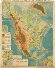
Extremely rare separately issued map of North America, the Caribbean and the Atlantic Ocean, issued by William Herbert in London.
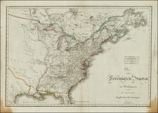
The Advertisement in the lower right corner notes that the chart was originally drawn and engraved by the late Mr. John Senex, F.R.S. and since corrected from latter improvements, especially the interior parts of North America . . . .
The map is richly annotated with information both within North America an in the Atlantic, including notes on La Salle's explorations and the headwaters of the Mississippi, with a note that "The head of the Missisipij River hath not been yet discovered by Europeans, but according to the Indians it lies in a very Marshy Country about the Latitude of 50 Degrees".
A line at 49 degree marks the "Southern Bounds of the Hudson's Bay Settled in Consequence of the Treaty of Utrecht." In the Arctic regions, a note identifies the "Irmuets a People inhabiting a Wild barren Country," and the point reached by John Davis in his search for the Northwest Passage in 1586.
The boundaries of most of the British Colonies extend to the Mississippi River, with a note to the west describing French Louisiana as !Country Not Particularly Well Known."
There are many forts, both English and French, as well as Fort St. John on the Rio Bravo. There are also some fascinating notes in the Atlantic regarding the location of little known (mythical?) islands and other details.
Rarity
The map is extremely rare.
While references to the Senex original can be found, there is no record of the map appearing on the market in the past 25 years and this example of the Herbert is the first to appear since offered by Jonathan Potter in 1997. This is the second example we have offered for sale in the past 30 years (2023).
The English mapmaker William Herbert (1718-95) traveled to India in about 1748 as a purser's clerk. Herbert's cartographic publishing started to take form in the late 1740s, when he set up a map and print shop on London Bridge. In 1758, with the encouragement of the East India Company, he introduced a new pilot guide, A New Directory for the East Indies. Herbert gathered superior sources than those used in Mount & Page's The Third Book, consulting such works as Mannevillette's Neptune Oriental, as well as the navigator William Nicholson and the cartographer Samuel Dunn. He often worked with colleagues, including Jefferys, Sayers, Dury, and Andrews, and is recorded as a seller of the famous Anti-Gallican map. In 1776 he retired, having apparently made a fortune. His business was carried on by Henry Gregory Sr.
![[ Promoting Emigration To The Czech Market ] Ceske Osady V Americe [ A Correct Map of the United States of America Showing Atchison, Topeka and Santa Fe R.R. and Connections ]](https://storage.googleapis.com/raremaps/img/small/101348.jpg)

![[Fruit Crate Label Advertising Map] Panama Brand (North America & Panama Canal)](https://storage.googleapis.com/raremaps/img/small/48860.jpg)