|
||

|

|
|

|
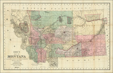
Stock# 94159
Description
Attractive lmap of Montana, colored by counties, from the deluxe Rand McNally & Co. New Indexed Atlas.
Shows the extend of the surveys in Montana, along with towns, mountains, rivers, forts, Indian reservations, national cemetaries, post offices, mines, railroads, etc.
Inset of the territory between Butte and Helena.
![[ Idaho Below Montana ] Verein-Staaten am Stillen Ocean… [inset of San Francisco Bay] [Unusual Idaho & California configurations]](https://storage.googleapis.com/raremaps/img/small/99297.jpg)