


|
||

|

|
|

|
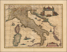
An exceptional representation of early 17th-century cartography, this striking map of Italy—created by Jan Jansson in Amsterdam, circa 1635—is notable for its remarkable embellishments, including detailed cartouches, seafaring vessels, mythical sea creatures, and a famous depiction of Neptune alongside his consort.
The striking features of the map include not only geographical details but also imaginative renderings that reflect the period's fascination with mythology and sea lore. Dominating the visual narrative is a vivid depiction of Neptune, the Roman god of the sea, engaged in an embrace with his consort, a holdover from the contentious imagery found in the first edition of Ortelius' map of Italy. These elements bring to life the spirit of exploration and maritime adventures that characterized the era, adding a layer of charm to the cartographic precision.
In the historical context of Italy, the map also features the twin founders of Rome—Romulus and Remus—in the lower right corner. An illustration below the cartouche captures a compelling depiction of the brothers' legendary origins, showing them nursing from a she-wolf, a pivotal narrative in the mythology of Rome's founding. This inclusion bridges the geographical present with the mythical past, underlining the enduring influence of Rome's foundational legend in the collective consciousness.
Overall, this map embodies the blend of scientific advancement in cartography with the creative sensibilities of the 17th century. It serves as a testament to the era's progress in geographical representation and its embrace of the mythical and historical narratives that shaped the cultural identity of the regions it depicted.
Jan Janssonius (also known as Johann or Jan Jansson or Janszoon) (1588-1664) was a renowned geographer and publisher of the seventeenth century, when the Dutch dominated map publishing in Europe. Born in Arnhem, Jan was first exposed to the trade via his father, who was also a bookseller and publisher. In 1612, Jan married the daughter of Jodocus Hondius, who was also a prominent mapmaker and seller. Jonssonius’ first maps date from 1616.
In the 1630s, Janssonius worked with his brother-in-law, Henricus Hondius. Their most successful venture was to reissue the Mercator-Hondius atlas. Jodocus Hondius had acquired the plates to the Mercator atlas, first published in 1595, and added 36 additional maps. After Hondius died in 1612, Henricus took over publication; Janssonius joined the venture in 1633. Eventually, the atlas was renamed the Atlas Novus and then the Atlas Major, by which time it had expanded to eleven volumes. Janssonius is also well known for his volume of English county maps, published in 1646.
Janssonius died in Amsterdam in 1664. His son-in-law, Johannes van Waesbergen, took over his business. Eventually, many of Janssonius’ plates were sold to Gerard Valck and Pieter Schenk, who added their names and continued to reissue the maps.
![Il Monferrato . . . [and] Parte Settentrionale Del Monferrato](https://storage.googleapis.com/raremaps/img/small/33919.jpg)

![(Russian Language FIFA World Cup Poster) 14 й- ЧЕMПИОНАТ МИРА по ФУTБОАУ | Italia '90 [14th Soccer World Championship]](https://storage.googleapis.com/raremaps/img/small/89589.jpg)
![(Monaco to Grimaldi di Ventimiglia) Carte des Costes d'Italie depuis Monaco jusqu'a La pointe de Murtera [Map of the Coasts of Italy from Monaco to the Point of Murtera]](https://storage.googleapis.com/raremaps/img/small/92355.jpg)