|
||

|

|
|

|
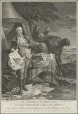
George Washington Family Land Speculation Artifact on CSA Watermarked Paper
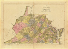
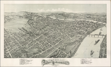
Fascinating map of the area around Ravenswood, West Virginia on the Ohio River, almost certainly related to the circa 1795 acquisition by George Washington of lands owned by Albert Gallatin and Jean Savary, in about 1795, shortly before the Washington family established the town of Ravenswood, Virginia (now West Virginia).
The present map is an early (Civil War era) hand drawn copy of an area map which provides an overview of the area likely intended for land speculation purposes. A note at the right gives a general description of the location of the surveyed lands, between Big Sandy Creek and Little Sandy Creek, as well as its location above Mill Creek and Great Kanawa River, two major landmarks in the area and, more importantly, landmarks in an ongoing discussion between the major landowners in the region, Jean Savary & Albert Gallatin, with the other major landowner on the Ohio River shown on the map, George Washington.
Oriented with east at the top, the map shows the area centered on Ravenswood, West Virginia, on land where Washington and his heirs would plat the town of Ravenswood in 1810. The map shows the surveyed land ownership interests of a Jackson County, Virginia (now West Virginia), with the owners along the river including George Washington, Benjamin Harrison, Albert Gallatin and French real estate speculator Jean Savary. The map almost certainly relates a possible land transaction described by Savary in his Letter to George Washington dated March 19, 1795, wherein Savary identifies three parcels of land which he and Gallatin owned (on Sandy Creek, Mill Creek and Great Kanawa) and states as follows:
Excellency
In order to conciliate your paternal intentions for the Welfare of the people at large, essentially of that reccomandable class of poor farmers, and your private interests, I have framed the present scheme for your properties on the Ohio river, at my best to meet your approbation.
Although the pretention of your Excellency of one guinea by acre appear not excessively dear, considering the soil in general & the situation of those tracts; nevertheless now, and may be, for some years to come, it will be difficult, I believe, to sell at that price of 35/. The Western country and the lands in Pensilv. and Newyork to dispose of, offers a field so extensive to the Speculation, that it is not possible to foresee yet the time when the lands on Ohio river will take a proportionate value to their quality; Then in such circonstances, it appears convenient to give a real value to those tracts of land, instead of an ideal one, that they have now for speculation, and also to anticipate the sooner possible that real value, by some scheme, reuniting the public good with the private interest.
The respective distance from one to another of those tracts of land at the mouth of little Kanhawa, at that of Sandy creek, and at that of mill creek, admit the convenient project of settlement of a town on two of them and on the spot the most eligible after further examen; one at the mouth of little Kanhawa and the other at the mouth of Mill creek, or Sandy creek as the situation will admit more convenient.
I will expose candidly my ideas to your Excellency as if all your possessions on the Ohio river were my own property and although I mention only those two tracts, it is certain that the others will take a proportionate value, according to their proximity of the said projected settlements. . . .
Ravenswood was laid out on land once owned by George Washington. Washington acquired the 2,448-acre parcel in 1770, and designated Colonel William Crawford to survey the lands in 1771. A permanent settlement was first established in 1810, and the town streets and lots were laid out in their current pattern by descendants of Washington in 1835.
The other major landowners shown on the property including Albert Gallatin (Swiss-born US Senator, Foreign Diplomat, and Secretary of the Treasury under Thomas Jefferson) and Jean Savary. After settling in America, Gallatin disliked living in New England, instead preferring to become a farmer in the Trans-Appalachian West, which at that point was the frontier of American settlement. He became the interpreter and business partner of a French land speculator, Jean Savary de Valcoulon and traveled throughout various parts of the United States in order to purchase undeveloped Western lands, prior to his becoming an American citizen in 1785.
The map identifies itself as covering lands largely surveyed in an before 1794, as follows:
All the lands herein designated were entered and Surveyed in Monongalia County (before the line which divides it now Wood, from Greenbriar, now Mason had been ascertained) with the exception of Gallatin tract of 5676 3/4 acres which was entered and Surveyed in Kenawa County, in September 1794. Grant issued July 1795. It now lies in Jackson County.
The map identifies numerous early land owners, including:
- General Washington 2448 Acres
- Benjamin Harrison
- Formerly Savary & Gallatin 1500 Acres
- Formerly Savary & Gallatin 9000 Acres
- Formerly Savary & Gallatin 7200 Acres
- Albert Gallatin 5676 3/4 Acres
- Henry Banks (multiple tracts)
- Davis 800 Acres
- John Allison (multiple tracts)
The map is watermarked CSA 8 times. This watermark is identifiable as paper made in the Confederate States of America during the Civil War.
Ravenswood, West Virginia and George Washington
Ravenswood, West Virginia, located in Jackson County, along the left bank of the Ohio River, has a rich history intricately linked with the colonial era and the early development of the United States.
The history of Ravenswood is closely tied to the Washington family due to their extensive landholdings in the region. Before it became a city, the area that is now Ravenswood was part of the vast tracts of land surveyed and claimed by George Washington and his family. Washington, a skilled surveyor from an early age, conducted extensive surveys in the Ohio Valley and western territories, which eventually became West Virginia. His diary entries in the 1760s cover his surveying work in this area. Washington recognized the economic potential of these lands, particularly for farming and trade, given their accessibility to important waterways like the Ohio River.
First platted in 1810, it was George's brother Charles Washington's son, George Washington Adams, who eventually founded Ravenswood in 1835.
![[Inhabitants of Virginia] Einwohner von Virginia](https://storage.googleapis.com/raremaps/img/small/94084.jpg)