|
||

|

|
|

|
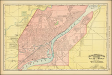
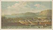
Rare early view of Toledo, Ohio, drawn by Albert Ruger, published by J.J. Stoner of Madison, Wisconsin, and printed in Chicago by Charles Shober & Company.
As note on the Library of Congress website:
This panoramic map shows Toledo, Ohio, as it appeared in 1876. . . . The map shows a busy harbor and major points of interest, including freight elevators, the city’s many churches, and the depot of the Lake Shore & Michigan Southern Railway, the main rail line between Chicago and Buffalo.
The panoramic map was a cartographic form in popular use to depict U.S. and Canadian cities and towns in the late 19th and early 20th centuries. Also known as bird's-eye views or perspective maps, these maps are representations of cities portrayed as if viewed from above at an oblique angle. Not generally drawn to scale, they show street patterns, individual buildings, and major landscape features in perspective.
This map is by Albert Ruger (1829–99), the first American to achieve success as a panoramic artist. Born in Prussia, Ruger immigrated to the United States and worked initially as a mason. While serving with the Ohio Volunteers during the Civil War, he drew views of Union campsites. After the war, Ruger settled in Battle Creek, Michigan, where he began his panoramic mapping career by sketching Michigan cities. In the late 1860s, Ruger formed a partnership with J.J. Stoner of Madison, Wisconsin, and together they published numerous city panoramas.
Rarity
The view is very rare. We note only a single example at auction in the past 30 years.
OCLC locates 4 examples.
The following is excerpted from the Library of Congrss Website:
Albert Ruger was the first to achieve success as a panoramic artist. The collections of the Library's Geography and Map Division contain 213 city maps drawn or published by Ruger or by Ruger & Stoner. The majority came from Ruger's personal collection, which the Library purchased in 1941 from John Ramsey of Canton, Ohio. Before this accession, there were only four Ruger city plans in the Geography and Map Division. Born in Prussia in 1829, Ruger emigrated to the United States and worked initially as a mason. While serving with the Ohio Volunteers during the Civil War, he drew views of Union campsites, among them Camp Chase in Ohio and Stephenson's Depot in Virginia. He continued to draw after the war, and his prints include a famous lithograph of Lincoln's funeral car passing the statehouse in Columbus, Ohio.
By 1866, Ruger had settled in Battle Creek, Michigan, where he began his prolific panoramic mapping career by sketching Michigan cities. Full descriptions of many Ruger views of Michigan cities are contained in John Cumming's A Preliminary Checklist of 19th Century Lithographs of Michigan Cities and Towns. Urban communities in some twenty-two states and Canada, ranging from New Hampshire to Minnesota and south to Georgia and Alabama, were sketched by Ruger. He continued his activity into the 1890s, moving his business to Chicago, Madison, and St. Louis as he sought new markets. In the late 1860s, Ruger formed a partnership with J. J. Stoner of Madison, Wisconsin, and together they published numerous city panoramas. Ruger was particularly productive during the 1860s; in 1869 alone, he produced more than sixty panoramic maps. In addition to city plans, he drew views of university campuses, among them Notre Dame, Shurtleff College, and the University of Michigan. Albert Ruger died in Akron, Ohio, on November 12, 1899.
![Cincinnati. From Covington [Letter from Philipp Holzmann]](https://storage.googleapis.com/raremaps/img/small/84432.jpg)