|
||

|

|
|

|
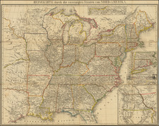
This untitled map of the United States by Rand McNally & Co., printed in Chicago in 1893, offers a nuanced depiction of the nation, notably highlighting a divided Oklahoma and Indian Territory and illustrating the extensive railroad networks of the era. It serves as an embodiment of a transformative moment in American geography and the advancements of cartographic technologies at the end of the 19th century.
The late 19th century marked a period of substantial change in the United States. The wounds of the Civil War had begun to heal, and the nation was rapidly expanding westward. The division between Oklahoma and the Indian Territory depicted in this map offers a reflection of policies that relegated Native American tribes to specific regions before Oklahoma achieved statehood in 1907. The recognition of these territories provides insight into the ever-evolving nature of American boundaries and the sociopolitical dynamics of the time.
The plethora of railroads illustrated is a testament to the era's feverish railroad expansion. With the completion of the First Transcontinental Railroad in 1869, the country embarked on a rail-building spree that continued for decades, accelerating commerce, migration, and urbanization. In this map, the intricate web of railroads mirrors the nation's industrial prowess and its relentless drive to connect the vast expanse of its territories.
Lastly, the craftsmanship of Rand McNally & Co., a distinguished publisher in cartographic design, is evident. Their dedication to accuracy and the intricate detailing on the map reflect the professional standards of the day. This piece not only offers geographical insights but also serves as a window into the United States during a period marked by growth, innovation, and profound change.
Rand McNally & Co. is a large American map and navigation company best known for its annual atlases. The company got its start in 1856, when William Rand opened a print shop in Chicago. He was joined in 1858 by a new employee, Andrew McNally. Together, the men established their namesake company in 1868. Originally, the company was intended to print the tickets and timetables for the trains running to and through Chicago; their first railway guide was published in 1869.
By 1870, they had shifted from just printing to publishing directories, travel guides, and newspapers. Their first map appeared in 1872 in a railway guide. The map was produced using a new wax engraving method, a cheaper process that gave the company an edge.
By 1880 Rand McNally had entered the education market with globes, wall maps, and geography texts for students. In 1923, Rand McNally published the first Goode’s World Atlas, named after its editor, Dr. J. Paul Goode. For generations afterward, this would be the standard classroom atlas.
In 1899, William Rand left the company, but McNally and his family remained, controlling the company for over a century. In 1904, they published their first road map intended for automobiles and by 1907 were publishing Photo-Auto Guides, which combined photography and mapping to help drivers. In 1924, they produced the Auto Chum, a precursor to their famous road atlases. Rand McNally would remain the leader in road maps and atlases throughout the twentieth century.
In 1937, Rand McNally opened its first store in New York City. Ever on the frontier of technology, Rand McNally pioneered the scribing process for printing tickets in 1958 and printed their first full-color road atlas in 1960. Arthur Robinson developed his now-famous projection of Rand McNally in 1969. By the 1980s, the company was exploring digital reproduction and digital databases of maps for truckers. In the 1990s, they lead the charge to develop trip-planning software and websites. Today, most of its products are available online or in a digital format, including maps for tablets and phones.
![The United States of America Confirmed By Treaty 1783 [shows Franklinia]](https://storage.googleapis.com/raremaps/img/small/84491.jpg)
![A Geographical Chart: or, A Scheme, Comprehending The Most Important Particulars Relative To The Geography of North and South-America. : Designed to be an Auxiliary to the Student. Carefully Compiled from the Best authorities, by Amos Bingham [Copy-Right Secured]](https://storage.googleapis.com/raremaps/img/small/41406.jpg)