|
||

|

|
|

|
A rare antique map of the Persian Gulf and Gulf of Oman. Designed for navigational use by the French East India Company, this map is neatly designed and shows rhumb lines, bathymetric soundings, prevailing currents, and shoals. This chart is designed solely for navigation and no features which cannot seen from the coast are included.
The map includes an early reference to Qatar. The town labelled Deh-Rogn on an island near the coast of Bahrain transliterates to "the village at Ras Rakan," referring to a geographical feature of a small spit at the northernmost point of the peninsula. Interestingly, an island labelled Samaca lies to the east, so Qatar and Bahrain may have been interchanged on this map. The area to the south of Qatar is described as "little frequented, thus little known." Other geographical details are overlooked, especially in the south of the map near the present day United Arab Emirates. The pearl banks of the southern gulf are yet to become famous and remain unmarked. Some inaccuracies are recorded in the map, such as Daba [Dubai] being placed on the Omani coast.
About the map, Biedermann says "It is interesting to note that, despite the fact that the shape of the Gulf is rooted in the Dutch tradition that we have come to name after Cornelis Roobacker, there are many new place names that were not there in the earlier decades. Like some other items from this period, this map is thus a precious document of the shifting commercial geography of Persia and the Persian Gulf" (Historical Atlas of the Persian Gulf, p. 290).
Inset map of Khark and Kharko and the harbor of Bandar Rig in the northern Gulf. Bandar Rig was controlled at the time by Mir Muhanna, and was the scene of frequent small conflict during the period. The port was desired by the Dutch and British East India Companies, though Mir Muhanna repeatedly defended the area to varying degrees of success. See Cambridge History of Iran, Volume 7, pages 86-89.
This is from the Oriental Neptune, plate 28. Published from 1745 to 1775. The 1775 version as can be discerned from the addition of details including Deh-Rogn and the updated inset map.
Jean-Baptiste Nicolas Denis d’Après de Mannevillette (1707-1780) was a French sailor and hydrographer celebrated for his excellently-rendered charts. Mannevillette was born into a maritime family and he joined his father on a French East India Company voyage to India aged only twelve. A clever boy, he returned to France to study navigation, chartmaking, and mathematics with Joseph-Nicolas De L’Isle. At nineteen, he was back at sea, working his way up the ranks of the French East India Company’s merchant fleet.
In his work with the company—he was eventually promoted captain—Mannevillette sailed to the Indian Ocean many times. En route, he was constantly gathering and correcting hydrographic knowledge. He was also skilled at using the latest navigational instruments, like the octant and later the sextant, which allowed him to make his charts especially accurate for their time. He compiled his work into his most significant publication, Le Neptune Oriental, which was commissioned by the French East India Company and first published in 1745. It was released in an expanded second edition in 1775, with posthumous expansions in 1781 and 1797.
The Neptune earned Mannevillette many accolades. The company made him Director of Charts at Lorient in 1762. In 1767, King Louis XV gave him the Order of St. Michael and named him an associate of the Royal Marine Academy.
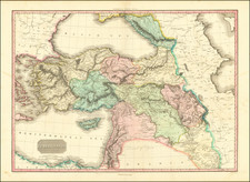
![[Peninsula of Qatar shown] Map of Persia, Arabia, Turkey in Asia, Afghanistan, Beloochistan](https://storage.googleapis.com/raremaps/img/small/100289.jpg)
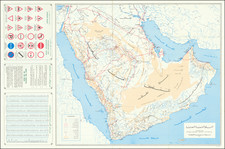
![[Jubail, Saudi Arabia]. Location of Archaelogical Sites - Jubail Area](https://storage.googleapis.com/raremaps/img/small/82295.jpg)