|
||

|

|
|

|
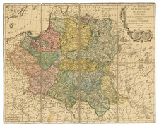
Striking regional map of Germany, centered on the Wesel, Leine and Oker Rivers and the Cities of Gottingen, Hildesheim, Hanover, Brunswyk, Wolfenbutel and Goslar. Also showns Minden, Hamelen, Heiigenstat, Dudetstat, Halberstat, and Zell.
Large decorative cartouche includes the coasts of arms of Braunsweig, Halberstat, Schawenburg, Hohenstein, Rheinstein, Blankenberg, Stolberg and Wernigeroda. A bit of dampstaining at the centerfold, but generally a nice example. Shows roads, rivers, lakes, mountains, towns, fortified cities, etc.
Johann Baptist Homann (1663-1724) was a mapmaker who founded the famous Homann Heirs publishing company. He lived his entire life in Bavaria, particularly in Nuremberg. Initially, Johann trained to become a priest before converting to Protestantism and working as a notary.
In 1702, Johann founded a publishing house that specialized in engravings. The firm flourished, becoming the leading map publisher in Germany and an important entity in the European map market. In 1715, Johann was named Imperial Geographer to the Holy Roman Empire by Charles VI and made a member of the Prussian Academy of Sciences. Most importantly for his business, his reputation and contacts gained him imperial printing privileges which protected his publications and recommended him to customers. Johann is best known for this Grosser Atlas ueber die ganze Welt, or the Grand Atlas of the World, published in 1716.
After Johann died in 1724, the business passed to his son, Christoph (1703-1730). Upon Christoph’s early death, the company passed to subsequent heirs, with the name of the company changing to Homann Erben, or Homann Heirs. The firm continued in business until 1848.
![(Second World War - Occupation of Germany) Карта Группировки Союзных Оккупационных Войск в Германии по УКА ГСОВ в Германии [Map of the Grouping of the Allied Occupation Forces in Germany according to the UKA GSOV in Germany] | Административное Деление Германии на 1 июня 1939 Года [Administrative Division of Germany on June 1, 1939]](https://storage.googleapis.com/raremaps/img/small/72174.jpg)

![[First Postwar Elections in Germany] Elections au Bundestag 14 Aout 1949 Zone Francaise](https://storage.googleapis.com/raremaps/img/small/78830.jpg)