|
||

|

|
|

|
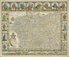
Herman Moll's map of the northwestern part of Germany, published in London in 1729, offers a detailed view of the region during the early 18th century.
This map includes the dominions of the Electors of Brunswick, Lunenberg, and Cologne, along with Westphalia, the Duchy of Holstein, Jülich, and others. It also illustrates the Landgraviate of Hessen Cassel and the bishoprics of Münster and Osnabrück.
Noteworthy here is the historical context of the map. During this period, Germany was not a unified nation but a complex mosaic of independent kingdoms, duchies, bishoprics, and other territories. The Electors referred to were important figures within the Holy Roman Empire, who held the privilege of participating in the election of the emperor.
Moll's maps are highly regarded for their aesthetic quality as well as their accuracy. This particular map would likely have been appreciated not just for its practical value, but also as a work of art. Detailed and carefully rendered, it provides valuable insight into the political and geographical landscape of northwestern Germany during the early 18th century.
Herman Moll (c. 1654-1732) was one of the most important London mapmakers in the first half of the eighteenth century. Moll was probably born in Bremen, Germany, around 1654. He moved to London to escape the Scanian Wars. His earliest work was as an engraver for Moses Pitt on the production of the English Atlas, a failed work which landed Pitt in debtor's prison. Moll also engraved for Sir Jonas Moore, Grenville Collins, John Adair, and the Seller & Price firm. He published his first original maps in the early 1680s and had set up his own shop by the 1690s.
Moll's work quickly helped him become a member of a group which congregated at Jonathan's Coffee House at Number 20 Exchange Alley, Cornhill, where speculators met to trade stock. Moll's circle included the scientist Robert Hooke, the archaeologist William Stuckley, the authors Jonathan Swift and Daniel Defoe, and the intellectually-gifted pirates William Dampier, Woodes Rogers and William Hacke. From these contacts, Moll gained a great deal of privileged information that was included in his maps.
Over the course of his career, he published dozens of geographies, atlases, and histories, not to mention numerous sheet maps. His most famous works are Atlas Geographus, a monthly magazine that ran from 1708 to 1717, and The World Described (1715-54). He also frequently made maps for books, including those of Dampier’s publications and Swift’s Gulliver’s Travels. Moll died in 1732. It is likely that his plates passed to another contemporary, Thomas Bowles, after this death.
![[ Duchy of Schleswig ] ucatus Slesvicensis in omnes ejusdem Generales et Particulares Praefecturas exactè divisi Nova tabula, edita](https://storage.googleapis.com/raremaps/img/small/104365.jpg)
![[Fascist Organizations of Germany] Фашистские Организации Германии](https://storage.googleapis.com/raremaps/img/small/67801.jpg)