


|
||

|

|
|

|
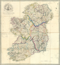
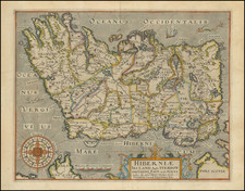
Rare Dublin-published map of Ireland, published in Dublin in 1834.
It is unusual to see maps of Ireland published in Dublin at this time, making this map a scarce and interesting piece. The map is titled "Ireland. From the Best Authorities, with The Distances laid down in British Statute Miles" and is hand-colored in outline. It provides detailed geographical information of the country.
This map was produced before the Great Famine, which began in 1845. It offers a glimpse into Ireland during a time of significant political and social change, including the rise of nationalist movements and the country's continued tumultuous association with the United Kingdom. It is an essential resource for those studying the history of Ireland in the 1830s.
In the 1830s, Ireland was part of the United Kingdom and was heavily influenced by British rule. The map's inclusion of distances in British statute miles reflects the country's association with the UK at the time.
This map is an interesting and valuable resource for those studying the history of Ireland in the 1830s. It provides detailed geographical information and a unique perspective on the country during this time period.
The title cartouche includes a crowned harp.

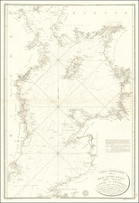
![(British Isles) Tabu Moder Anglie & Hiber [Modern Map of England and Ireland]](https://storage.googleapis.com/raremaps/img/small/103164.jpg)