|
||

|

|
|

|
Stock# 89526
Description
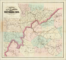
Scarce map of Virginia and West Virginia, published by OW Gray & Son.
The map is colored by counties and showing towns, roads, railroads, post offices, etc.
Includes insets of Hampton Roads, Norfolk Harbor, the Panhandle and western part of Virginia.
A marvelous detailed map.
O.W. Gray Biography
O. W. Gray was a publishing firm based in Philadelphia. Later, they published as O. W. Gray & Son. They published atlases in the late nineteenth century. Gray's National Atlas was one of the most successful commercial ventures of the 1870s and one of the last to employ hand coloring on maps.
![(American Revolution - Virginia Privateering) Manuscript Document Concerning the American Privateer Grand Turk, Captured Near Scotland's Fair Isle by Michael Griff [The Capt. of the Privateer Michael Griff declares as follows ...]](https://storage.googleapis.com/raremaps/img/small/82328.jpg)