|
||

|

|
|

|
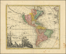
The enduring legacy of Sebastian Munster's Cosmography was maintained well beyond his death in 1552, initially by Henri Petri and, following Henri's passing in 1579, by his son, Sebastian Petri. In 1588, undertaking the monumental task of modernization, Sebastian Petri initiated a project to revise the outdated woodblocks, one of which depicted the Americas. The result is this striking woodcut map titled Americae Sive Novi Orbis Nova Descriptio, a testament to late 16th-century cartographic understanding, serving as an impressive representation of the Americas at the end of that momentous century.
The map's prominent features include two oval cartouches that traverse its top, presenting descriptions of the "New World," its discovery in 1492, and its vast geographical expanse. Further, these cartouches shed light on the territorial claims of the time, referencing the Portuguese dominion over Brazil and the French control over "Nova Francia," with the rest belonging to the Spanish king. These annotations speak volumes about the colonial aspirations and geopolitical dynamics of the European powers during the Age of Discovery.
Following the death of Henri Petri, the original publisher of Munster's successful book "Cosmographey," his son Sebastian took over and began updating the woodblocks with more contemporary examples. A significant point of focus was the map of America, which had become outdated. The updated map draws upon the copperplate map of America by Abraham Ortelius, yet, intriguingly, it maintains the southern bulge on the Chilean coastline, even though Ortelius himself removed this feature by 1587. The map also replicates the typical Ortelian western coastline of North America and the large, unexplored southern continent. Despite the attempt to update, the map paradoxically held onto the older portrayal of South America. The map, therefore, serves as a fascinating testament to the era's cartographic advancements and missteps, illustrating the evolving understanding of the "New World" amidst the transitional period of geographical exploration.
Münster's Cosmographia was the first German-language description of the world, and one of the defining books of the Renaissance. It contained 471 woodcuts and 26 maps over six volumes. First published in 1544, the Cosmographia was hugely popular in addition to being influential for contemporary cartographers like Mercator and Ortelius. It was published in at least 35 editions by 1628; these editions included examples in Latin, French, Italian, English, and Czech. After Münster's death, Henri Petri, and later his son, Sebastien Petri, took charge of printing editions.
Münster drew from his own travels in the work in addition to using other ancient and more modern sources. These sources included Herodotus, Strabo, and Titius Livius, as well as Marcantonio Sabellico, Beatus Rhenanus, and Aegidius Tschudi. Münster additionally collected reports from recent travelers, which he integrated into his descriptions. These descriptions generally included detailed overviews of the customs, dress, and organization of peoples around the world, earning him a prominent place in the histories of geography and anthropology.
Sebastian Münster (1488-1552) was a cosmographer and professor of Hebrew who taught at Tübingen, Heidelberg, and Basel. He settled in the latter in 1529 and died there, of plague, in 1552. Münster made himself the center of a large network of scholars from whom he obtained geographic descriptions, maps, and directions.
As a young man, Münster joined the Franciscan order, in which he became a priest. He then studied geography at Tübingen, graduating in 1518. He moved to Basel, where he published a Hebrew grammar, one of the first books in Hebrew published in Germany. In 1521 Münster moved again, to Heidelberg, where he continued to publish Hebrew texts and the first German-produced books in Aramaic. After converting to Protestantism in 1529, he took over the chair of Hebrew at Basel, where he published his main Hebrew work, a two-volume Old Testament with a Latin translation.
Münster published his first known map, a map of Germany, in 1525. Three years later, he released a treatise on sundials. In 1540, he published Geographia universalis vetus et nova, an updated edition of Ptolemy’s Geographia. In addition to the Ptolemaic maps, Münster added 21 modern maps. One of Münster’s innovations was to include one map for each continent, a concept that would influence Ortelius and other early atlas makers. The Geographia was reprinted in 1542, 1545, and 1552.
He is best known for his Cosmographia universalis, first published in 1544 and released in at least 35 editions by 1628. It was the first German-language description of the world and contained 471 woodcuts and 26 maps over six volumes. Many of the maps were taken from the Geographia and modified over time. The Cosmographia was widely used in the sixteenth and seventeenth centuries. The text, woodcuts, and maps all influenced geographical thought for generations.
![[Portrait] L'Amerique.](https://storage.googleapis.com/raremaps/img/small/79745.jpg)