|
||

|

|
|

|
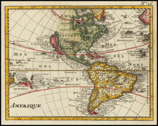
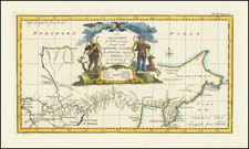
A Remarkable Seventeenth-Century Wall Map of America with Decorative Panels
Fine old color example of Willem Janszoon Blaeu's early wall map of America, here in the so-called anonymous Venetian edition of 1646.
The map is an excellent example of the mapmaker's art from a time when wall maps became an important part of the public and private decor across Europe. In the seventeenth century, wall maps were elevated as symbols of worldliness and curiosity, as the European mercantile elite and aristocratic classes accumulated much wealth through overseas commerce.
Today, all such wall maps are great rarities. They were very expensive and technically difficult to produce, and so were issued in very limited quantities. Moreover, their large size and the manner in which they were displayed made them especially vulnerable to damage, such that very few examples survive to the present day. Most surviving examples of the Blaeu wall maps have survived without the decorative panels and are typically heavily restored or damaged, making this an extraordinary survival.
The present example, likely published in Venice by Stefano Scolari, retains much of the cartographic detail from the original 1608 Blaeu wall map of America, as corrected by Blaeu following the discovery of the Straits of Le Maire following Schouten and Le Maire's circumnaivgation (1615-1617).
One notable update not drawn from Blaeu can be found in the southern polar inset. Marked in the region noted as Terra Australis Incognita is "Ant(onius) van Diemen lant," an important early reference to the discovery of Van Diemen's land by Abel Janszoon Tasman on November 23, 1642. Below Van Diemens Land are the words, "Ollandia Nova detceta 1644," making this map one of the earliest printed maps to report Tasman's discoveries.
Willem Janszoon Blaeu's 1608 continental wall maps
In Amsterdam in 1608, Willem Janszoon Blaeu produced a set of large wall maps of Europe, Asia, Africa, and the Americas. Today, original examples of these maps, published by Blaeu himself, are exceptionally rare; a survey shows only one institutional example of the Asia map, in Dresden, for example. Despite the rarity of the original Blaeu maps, they had a colossal influence on European mapping of the continents in the seventeenth century, particularly through the many derivatives, reduced versions, and copies that they inspired.
In his magnum opus on early Dutch mapmaking, Gunther Schilder spends the better part of Volume V on Blaeu's set and its followers. While the original Blaeu maps practically never appear on the market today, the Italian and French derivatives appear more often. However, they are still extremely rare. The primary wall map versions were by Blaeu in 1608; Scaicki in ca. 1627 (Burden only notes the post 1667 examples); an anonymous Venetian version from ca. 1646; a French edition by Jaillot from 1669; and an Italian copy by Pietro Todeschi (engraved by Giuseppi Longi), from 1673.
Gunther Schilder (MCN V, page 189) introduces the Anonymous Venetian example of the Blaeu wall map set as follows:
. . . Blaeu's four wall maps [published] in Venice can probably be attributed to the engraver and publisher Stefano Scolari (1598-1650), who conducted a flourishing workshop for prints and maps in the house located at all'insegna delle Tre Virtu a S. Zulian. . . .
No copies are known of the first Venetian state of the walls maps of the four continents; only by way of an analysis of later states can we prove the existence of [a prior state]. A few facts will suffice here. . . . .The first Venetian state of the map of America did not yet incorporate Le Maire's discovery of the new sea link (which was added to the main map . . . ). On the inset map of the first state, Magallanica was larger, while the coastline of Terra del fuogo was removed on the later state and re-engraved farther south, thereby makeing more space for the plotting of the Strait of Le Maire (Streso lemaire) . . .
Rarity
This map is extremely rare. Burden notes a single example in American institutions (Library of Congress), as well as the example noted by Schilder in Perugia, copies in the National Maritime Museum, and in two private collections.
We are unaware of any examples appearing on the market at auction or in a dealer catalog in recent decades.
Willem Janszoon Blaeu (1571-1638) was a prominent Dutch geographer and publisher. Born the son of a herring merchant, Blaeu chose not fish but mathematics and astronomy for his focus. He studied with the famous Danish astronomer Tycho Brahe, with whom he honed his instrument and globe making skills. Blaeu set up shop in Amsterdam, where he sold instruments and globes, published maps, and edited the works of intellectuals like Descartes and Hugo Grotius. In 1635, he released his atlas, Theatrum Orbis Terrarum, sive, Atlas novus.
Willem died in 1638. He had two sons, Cornelis (1610-1648) and Joan (1596-1673). Joan trained as a lawyer, but joined his father’s business rather than practice. After his father’s death, the brothers took over their father’s shop and Joan took on his work as hydrographer to the Dutch East India Company. Later in life, Joan would modify and greatly expand his father’s Atlas novus, eventually releasing his masterpiece, the Atlas maior, between 1662 and 1672.