


|
||

|

|
|

|
Stock# 88324
Description
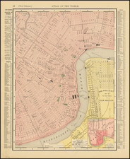
Detailed and interesting map of Louisiana, hand colored by parish, from Thomas, Cowperthwait & Co.'s New Universal Atlas.
The map is one of the best commercial atlas maps of Louisiana published during the period, showing towns, rivers, bays, lakes, railroads, swamps, etc. Table of Steam Boat routes and distances. Large inset map of New Orleans, colored by wards.
Condition Description
Minor dampstain in lower margin.
![Louisiana [inset:] Vicinity of New Orleans](https://storage.googleapis.com/raremaps/img/small/87567.jpg)
![[Florida to New Orleans] The North Coast of the Gulf of Mexico from St. Marks to Galveston . . . 1842](https://storage.googleapis.com/raremaps/img/small/83469.jpg)

![[ Tennessee / Louisiana / Mississippi / Alabama ] Boston Mountains (408) Radar AAF Aeronautical Chart](https://storage.googleapis.com/raremaps/img/small/97161.jpg)