


|
||

|

|
|

|
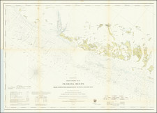
The Quintessential Domestically-Produced Mapping of Florida.
An attractive example of Columbus Drew's 1876 large pocket map of Florida.
Drew's maps of Florida are widely understood to be the defining maps of the state from the second half of the 19th century. They are also the first maps of the state published in Florida, following Searcy's unobtainable 1829 map, which was published in Tallahassee and Baltimore, Maryland.
This is the second large map of Florida produced by Drew; the first was titled New and complete township map of Florida and was published in 1856. The updated edition, Drew's New Map of the State of Florida, was published intermittently between 1867 and 1885. Taken as a series, the latter map charts the development of modern Florida, particularly its rail network, in impressive detail.
Rarity
All editions of both of Drew's maps are rare.
OCLC locates copies of the 1876 map at Yale and the Rumsey Library at Stanford.
This is the first time we have handled the 1876 edition.
Editions and States
The following is an accounting of the editions and states of Drew's two Florida maps, though the reference to state changes is by no means comprehensive.
New and complete township map of Florida.
1856. This was Drew's first venture into producing a map of Florida. As far as we can trace, there is a single edition of this title. The map is extremely rare, having appeared once on the market in the last 60 years. OCLC locates a single example, at Onondaga County Library.
Drew's New Map of the State of Florida
1867. First state. "Lith. of J. Bien, 24 Vesey St. N.Y."
1870. References have substantially changed but are still referred to as such.
1873. This issue has not been examined and is possibly phantom - based on the copyright date of 1873.
1874. The "References" section has been largely modified to "Memoranda," focusing more on battles, including the Battle Fields of Olustee, Natural Bridge, Pine Barren, and No. 4.
1875. Unexamined.
1876. The title date advanced to 1876. The Great Southern Railway has now been labeled "PROPOSED". Monroe County has taken over a large part of the Everglades from Dade County. There are probably other changes.
1877. Unexamined.
1884. Unexamined.
1885. The title date advanced to 1885. Many railroads, both projected and completed, are listed in the Atlantic. Some county borders have been subtly modified.
Provenance
Deaccession from Minnesota Historical Society, with their perforated stamp in the lower margin.
![[ Florida Native Americans ] Mulierum, quarum maritivel in bello caesi, aut morbo sublati posulata a Rege. XVIII.](https://storage.googleapis.com/raremaps/img/small/98052.jpg)
![[Florida Indians / Hermaphrodites] Hermaphroditorum officia. XVII.](https://storage.googleapis.com/raremaps/img/small/97966.jpg)
![[Florida Territory] North America XIV Florida](https://storage.googleapis.com/raremaps/img/small/95236.jpg)