|
||

|

|
|

|
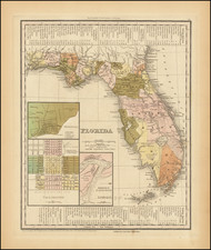
First state of this early map of Florida Territory, showing Monroe County, Mosquito County and the Seminole Indian lands in the southern part of the state and naming the Everglades for the first time.
Excellent early territorial map of Florida, being one of the earliest obtainable separate maps of Florida to appear in a commercial atlas. Shows early counties (approximately 20 counties), towns, roads, Indian paths, Indian villages, courthouses, lakes, rivers, bays, keys, forts, etc. Inset of the panhandle. One of the best early maps of Florida and certainly one of the most detailed.
The map was apparently taken from American sources, including HS Tanner. The Society for the Diffusion of Useful Knowledge was active from the 1830s through the 1860s and published some of the best regional maps of the era.

![The Coast of West Florida and Louisiana . . . [with] The Peninsula and Gulf of Florida or Channel of Bahama with the Bahama Islands . . .](https://storage.googleapis.com/raremaps/img/small/105350.jpg)

![[Florida Keys, Cuba, Bahamas, Cayman Islands] The Island of Cuba with part of the Bahama Banks & the Martyrs . . .](https://storage.googleapis.com/raremaps/img/small/85166.jpg)
![[ Death of a Florida Indian Chief ] Ceremoniae in Regis & Sacerdotum funere observatae. XL.](https://storage.googleapis.com/raremaps/img/small/97768.jpg)