|
||

|

|
|

|
Stock# 84986
Description
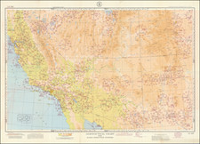
Topographical map of west-central Colorado by the U.S. Geological Survey in 1:250,000 scale, centered on Gunnison, with Montrose to its west. Grand Mesa, Rio Grande, Gunnison, Isabel, and Uncompahgre National Forests are shown. Colorado's first overhead chair lift, at Pioneer Ski Area along Cement Creek near State Highway 135, is marked as "Chair lift— Winter sports area." Neither Mount Crested Butte (site of Crested Butte Mountain Resort), a few miles to Pioneer's north, nor Monarch, east of Gunnison, is similarly shown as a ski area.
Condition Description
Some marginal creases. Light soiling in left margin.
![(Western Photographs) [Collection of 35 Albumen Photographs by Isaiah Taber, Norman Reed, W.H. Jackson and others: California, Arizona, New Mexico, Colorado]](https://storage.googleapis.com/raremaps/img/small/90506.jpg)
![Economical Features of S.W. Colorado, San Juan Mining Region [Atlas Sheet No. 61 (C)]](https://storage.googleapis.com/raremaps/img/small/88754.jpg)