|
||

|

|
|

|
The Mapa Comercial República de Colombia, edited by the Banco de la República and published in Bogota in 1931, provides an intricate depiction of Colombia's commercial zones and significant geographic features. Constructed on an astronomical survey by the Oficina de Longitudes and illustrated with data from various governmental departments, including Mines and Petroleum, Public Works, and others, this map marks an important survey of the economic activities and development of the country during the early 20th century.
The period of the 1930s in Colombia was characterized by significant economic and infrastructural expansion, influenced by the growing industries of oil, coal, gold, and agriculture. The map serves as a visual representation of this commercial landscape, categorizing regions by color to denote zones rich in various resources. Notable areas include the Zonas Petrolíferas, Zonas Carboníferas, and Zonas Cafeteras, among others, each of which contributes to understanding the distribution of natural wealth in Colombia during that time.
The detailed legend, accompanied by conventional signs, offers a rich guide to the country's geography and infrastructural features. This includes information on capitals, towns, altitudes, borders, transport lines, oil wells, volcanoes, and telegraphic stations. The inclusion of ongoing projects, such as proposed railroads and roads, illustrates the aspirations and developmental trajectory of the nation. The presence of international collaboration, with graphics produced in Madrid, Spain, also hints at Colombia's connection with global partners.
In the upper right corner the map includes an interesting inset, titled Cartela del Archipiélago de San Andrés y Providencia perteneciente a la República de Colombia. This shows Colombia's Caribbean island territories and an integral note also mentions Colombia's ownership of Los Cocos in the Pacific.
The Mapa Comercial República de Colombia stands as an invaluable historical document that captures Colombia's economic and geographical diversity in the early 20th century. It provides insights into the planning and categorization of commercial activities, the development of transportation networks, and the utilization of natural resources. Reflecting both the realities and aspirations of its time, the map offers a window into a dynamic period in Colombian history, characterized by growth, innovation, and international collaboration.
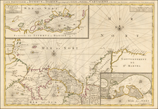
![[Colombia / Venezuela] Descripcion Del Destricto Del Audiencia Del Nuevo Reino](https://storage.googleapis.com/raremaps/img/small/64974.jpg)
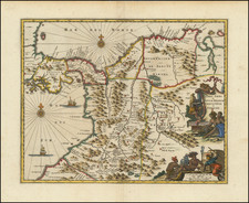
![[ Colombia ] Castilla D Oro](https://storage.googleapis.com/raremaps/img/small/99108.jpg)