|
||

|

|
|

|
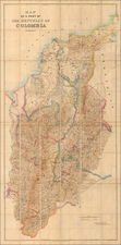
Rare separately published example of Manuel Maria Paz' map of the State of Santander.
The Comisión Corográfica, established in 1850, was a key project in the early Republic of Colombia, tasked with mapping and documenting the country's geography. This initiative was crucial for the young nation, seeking to understand and delineate its diverse landscapes and regions.
Manuel María Paz, a significant contributor to this commission, was responsible for creating many of the maps. His work is notable for its detailed depiction of Colombia's terrain, offering a clear view of the country's topographical features. Paz's maps are not only cartographic achievements but also serve as historical records, reflecting Colombia's geographical and cultural landscape in the mid-19th century.
The importance of the Comisión Corográfica lies in its role in documenting Colombia's physical and cultural geography during a formative period in its history. The maps produced by Paz and his colleagues provide a foundational understanding of the country's geography, valuable for historical and geographical studies.
These maps, while primarily functional in nature, also offer a glimpse into the past, showing how Colombia's landscapes and boundaries have evolved. The Comisión Corográfica, through the efforts of Manuel María Paz and others, played a crucial role in shaping the understanding of Colombia's geography in the 19th century.
![[ Peru, Ecuador and the Upper Amazon ] Maragnony sive Amazonum Fluminis Terrarum in Orbe Maximi quo ad Hispanicae Potestai subest Cursus cum Fluvys et Regionibus finitimis Utilitati Publicae probatissimis e Documentis accuratus novissime descriptus a quodam pereas provincias olim S.I. Missinario delineatus a Petro Parcar 1785](https://storage.googleapis.com/raremaps/img/small/89253.jpg)
![[ Manuscript Map of Province of Quito ] Carta de la Provincia de Quito i de sus adyacentes, obra postuma de Don Pedro Maldonado . . . Paris MDCCL](https://storage.googleapis.com/raremaps/img/small/98908op.jpg)
![[ Colombia ] Terra Firma et Novum Regnum Granatense et Popayan](https://storage.googleapis.com/raremaps/img/small/69943.jpg)