|
||

|

|
|

|
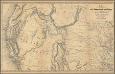
The 1848 map of Oregon Territory, California, and the region west of the Rocky Mountains, created by Carl Flemming of Glogau, is a marvelous depiction of the geographical and political landscape of the time. It offers a comprehensive view of the Oregon Territory, asserting the United States' claim to most of British Columbia by extending its boundaries to 54 degrees, 40 minutes.
The map is meticulously constructed to depict the topography of the region, along with identifying dozens of Indigenous Tribes.
One of the notable features of this map is the inclusion of a detailed inset map of the Columbia River. It encompasses the area from Fort Vancouver and Fort George to Astoria, showcasing the river's course as it flows into the Pacific Ocean. Additionally, a large inset of San Francisco Bay is presented, capturing the attention of viewers. It is worth noting that this map was published in the same year as the discovery of gold in California, adding to its historical significance.
Considered one of the most meticulous representations of the region, this map surpasses its contemporaries by offering a wealth of information. It showcases numerous forts such as MacKensie, Pitt, Hall, Bourse, Kutani, Okanagan, Vancouver, George, Umqua, Nesquatty, Kaoulis, Nes Perces, and others. The presence of early settlements, missions, a German monastery on the Nesqually River, fur trading stations, mountains, and elevations further enriches the map's content.
Moving south, the main map extends to Monterey, while also providing notes on the Sierra Nevada Mountains. It is believed that this map may have been influenced by the work of Duflot du Mofras, whose map of the Western United States was published shortly before Flemming's map.
A note in the Desert southwest of Lake Timpanagos reads: "The region between the Rocky Mountains and the Sierra Nevada consists of vast sandy plains devoid of vegetation and wildlife, which are frequently traversed by the Indians. The ground is commonly covered with a layer of salt crust, sparsely and scarcely along some small rivers, of which there are very few."

![(Photograph Album) [Southern California, Yellowstone, Pacific Northwest (Inside Passage), Alaska (Taku Glacier), Adeline Oil Co. at Maricopa, Kern County]](https://storage.googleapis.com/raremaps/img/small/91643.jpg)
![[ California To Alaska -- Northwest Passage ] Quivirae Regnu cum alijs versus Borea](https://storage.googleapis.com/raremaps/img/small/60083.jpg)