


|
||

|

|
|

|
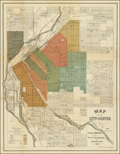
A Denver Rarity -- Transportation Lines!
Rare large map of Denver, issued in 1890 by the City Engineer, illustrating the location of Transportation Lines in Denver in 1890. Lines shown include:
- Cable Cars
- Electric Car Lines
- Horse Car Lines
- Steam Motor Lines
While the map is titled as accompanying and annual report, our research shows that it was likely only issued in 1890.
A rare map for the city showing the latest additions and developments. Includes detail for "River Front Park" along the Platte, which would later be wiped out in a flood. Still shows Lake Archer further upstream, with an island in the lake.
Shows Cherry Creek as still mostly unreclaimed river channel. Spans from Smith Lake near present day Washington Park, and reaches up to "North Highlands" and "Swansea"
The map bears a copyright date of 1887 and the name W.B. Gray.
Rarity
OCLC locates 4 examples of the map.
![[Leadville / Alma District] London Mountain Gold Mining Company](https://storage.googleapis.com/raremaps/img/small/69724.jpg)