|
||

|

|
|

|
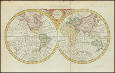
Detailed map of the World, showing tracks of some of the contemporary explorers, including Byron, Bouganville, and the Russian Voyages in the early 1740s to the NW Coast of America. NW Coast of America pre-dates Cook, but does not include the Sea of the West, although a prominent River of the WWEst extends from C. Blanco to Lake Winnepeg. Marvelous mythical coastal features are shown Southwest of the Straits of Magellan. New Zealand is shown (twice!!). Australia retains it's a mostly conjectural mid-18th Century Coastline. No sign of Antarctica. The NW Passage is left open. The early Behring discoveries are in evidence near Alaska and the Coast discovered in 1730 is noted. Gorgeous compass rose. From Dunn's New Atlas or Mundane System of Geography, printed for Robert Sayer at 53 Fleet Street, London. The true first state of the map. Wide clean margins and strong thick paper.
Samuel Dunn (bap. 1723-1794) was a teacher of mathematics and navigation who published, among other things, maps and charts. Although information about his early education is lacking, by age nineteen he was leading his own school and teaching writing, accounting, navigation, and mathematics in Devon. In 1751, he moved to London, where he taught in several schools and tutored privately.
By the 1760s, Dunn was known as a respected astronomer and had published a range of textbooks on math, navigation, and astronomy. After the publication of the Nautical Almanac, Dunn acted as a certifier of ships’ masters under the new system, on behalf of the Board of Longitude. He performed similar work for the East India Company, as well as made charts of the East Indies. In 1776 he published A New Variation Atlas and, in 1777, A New Epitome of Practical Navigation, or, Guide to the Indian Seas. By 1780, he was named editor of the New Directory for the East Indies, which included his own charts. In 1786, he released a pioneering study, Theory and Practice of Longitude at Sea. He also designed several instruments for navigation.
Dunn died at his home in Fleet Street in January 1794. His books and maps were auctioned at Sothebys in a sale of over 1,000 lots. Many of these were bought by Alexander Dalrymple, hydrographer of the East India Company and soon-to-be-named first head of the Hydrography Office.
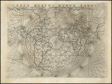
![[A Montage of a World Map by François Jollain, mounted within a series manuscript of religious rhetorical devices and cosmographical diagrams]](https://storage.googleapis.com/raremaps/img/small/27496.jpg)