|
||

|

|
|

|
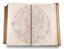
A Montage of a World Map by François Jollain, mounted within a series manuscript of religious rhetorical devices and cosmographical diagrams
This unique and fascinating montage is a powerful merger of contemporary science and cartography with Post-Tridentine Catholic propaganda. It features a printed double hemisphere map of the world, which has been cut out and mounted on a larger sheet of paper, which has been embellished with a rhetorically powerful combination of Roman Catholic iconography and cosmographical diagrams, all done in manuscript. The map features a roundel bearing the inscription “J.W. Brandt, Knechtsteden, 1692”.
The centerpiece of the work is François Jollain’s Nova Totius Terrarum Orbis Geographica ac Hydrographica Tabula (Paris, circa 1672), a rare, printed world map, based on Hondius’ famous world map of 1617. Cartographically, in North America, the St. Lawrence River is shown to run across the continent, ending in a large apocryphal lake, while Hudson’s Bay is derived from Hessel Gerritsz’s important 1612 map. In South America, the map includes the depiction of the Le Maire Strait, discovered in 1615. In the Far East, Korea is depicted as an island, while in the Antipodes, the northern coast of New Guinea is situated somewhat accurately, while below there appears the large landmass of “Terre Australle Incognue”.
Above the map is the potent symbol of the sun, inhabited by the Christogram “IHS”, abbreviating the Latin phrase “Iesus Hominum Salvator” (“Jesus, Savior of men”), surmounting a banner featuring the phrase “A solis ortu usque ad occasum laudabile nomen Domini” (“From the rising to the setting of the Sun the Name of the Lord is to be praised”). The message of this rhetorical iconography is that the Earthly sphere is under the power of God, and subject to the worship of the Lord by the true faith – the Roman Catholic Church. Such symbolism became an integral part of the ecclesiastical reforms and propaganda campaign mounted by the Catholic Church against the rise of Protestantism, beginning in the 1540s.
By the late 17th century, following a series of religious wars in Germany, Kloster Knechtsteden found itself located on the northern fringes of Catholic Europe, in the midst of avowedly Protestant lands, such as the Netherlands (Calvinist) and various Lutheran German states. As previously mentioned, even the religious affiliation of the Archbishopric of Cologne, for a time, hung precariously in the balance. In this climate, the monks of Knechtsteden would have felt an imperative to mount a rhetorical defense of their faith, creating a bulwark along the lines of sectarian schism in Europe.
Around the sides of the montage are a series of manuscript cosmographical diagrams, as well as banners noting the supposed dimensions of the earth, reflecting the Knechtsteden canons’ intellectual fascination with these subjects and their role within their theological outlook.
![Western Hemisphere [and] Eastern Hemisphere](https://storage.googleapis.com/raremaps/img/small/77454.jpg)
![[ Pacific Ocean Centric World Map ] Mappe-Monde Sur la Projection de Mercator Carte Encyprotype Dediée et Présentée à Monsieur](https://storage.googleapis.com/raremaps/img/small/69294.jpg)
![Typus orbis descriptione Ptolemaei [Verso title]](https://storage.googleapis.com/raremaps/img/small/103829.jpg)