|
||

|

|
|

|
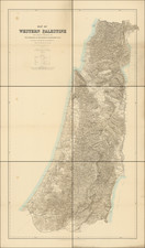
One of the Earliest Obtainable Printed Maps of Israel.
A handsome example of the Francesco Berlinghieri map of the Holy Land, published in Florence between 1480 and 1482.
The map is extremely rare on the market and therefore has perhaps not had the level of recent analysis due to it. This map's fundamental claim to fame is that is one of the first to relay the cartography of Marino Sanuto's Liber secretorum fidelium Crucis, from circa 1320. From the beginning of the 1480s onward, maps based on that Sanuto-Vesconte cartography became important additions to the Ptolemy atlases that dominated the early history of printed cartography, and as such they defined the earliest history of printed maps of what is now Israel.
Kenneth Nebenzahl, author of the groundbreaking cartobibliography Map of the Holy Land, includes the following essay on the Sanuto-Vesconte map of the Holy Land:
This "modern" map, copied directly from Sanuto and Vesconte by Donnus Nicholaus Germanus, is crucial for the development of Holy Land cartography during the early history of printing. It represents the second fundamental style, after Ptolemy's Asia Part IV, which determined the format for mapmakers of the sixteenth and seventeenth centuries. That the map was composed by Sanuto and Vesconte was no longer important; association with the atlases of Ptolemy assured its authority.
Nicholaus's copy is nearly identical to the 1320 original. Rivers, lakes, and mountains show the same basic contours, and the Mediterranean coast still has its characteristic bays and inlets. The boundaries of the Twelve Tribes are similar. A glance at the cities reveals a few discrepancies, but Sanuto-Vesconte's horizontal format and numerical grid are retained.
Nicholaus also made some improvements on Sanuto. Lines of latitude in the margin indicate that the orientation of Sanuto's map is actually to the southeast, not directly east; Nicholaus kept the format but indicated true north. The river Kishon no longer connects the Sea of Galilee with the Mediterranean, as it did according to Burchard of Mt. Sion's long-influential aberration. Some cities have been added, mostly from Ptolemy's Asia Part IV, and more information is conveyed in numerous inscriptions.
Nicholaus produced three manuscript versions of a Ptolemaic atlas between 1466 and 1474. These formed the basis for some of the first printed atlases, one at Rome in 1478, and two at Ulm in 1482 and 1486. The printed atlases contained Sanuto and Vesconte's map of Palestine as a modern map, linking them with the Ptolemaic canon.
Ptolemaic manuscripts had been supplemented by modern delineations as early as 1428, when a copyist inserted a map of the north by Claudius Clavus. Hugo de Comminellis produced a Ptolemy atlas with a section of modern maps in November 1469. Nicholaus, in his third revision of Ptolemy, quickly adopted Comminellis's original idea, adding Sanuto's map of the Holy Land for the first time.
The Sanuto-Vesconte map had not been improved substantially for over 150 years, and it was destined to provide the basic image of the Holy Land until the eighteenth century. It proved itself an appropriate addition to Ptolemy's classical geography.
The present map of the Holy Land is one of four "modern" (i.e., non-Ptolemaic) maps included in 1482 Florence Geographia. The others are of Italy, Spain, and France.
This map and the 1482 Ulm version are both based on the Vesconte-Sanuto and were published at approximately the same time, however their cartography differs, indicating that they were based on different manuscript models, as is generally accepted. The Berlinghieri makes notable changes to the mountains at the top of the map and to the Mediterranean coastline.
Rarity
The map is extremely rare on the market; we were unable to trace any examples for sale in OldMaps.com and RBH.
This is the first time we have had the map.
Francesco Berlinghieri (1440-1501) was a Florentine engraver. Nicolas Laurentii published Berlinghieri's edition of Ptolemy, which was written in Italian terza rima, comprising 123 folios of text and 31 engraved maps. The work was first printed in 1482, but most surviving examples come from the edition of 1486, which was the first edition to include red printing in the title page. The full title is Geographia. In Questo Volume Si Congengono Septe Giornate Della Geographia Di Francesco Berlingeri Fiorentino Allo Illustrissimo Federigo Duca . . .
Berlinghieri's edition of Ptolemy is unique, in that it includes 31 maps covering Europe, northern Africa and the south part of Asia and is the first atlas to attempt the introduction of modern geography, with the inclusion of four new maps - France, Italy, Spain and Palestine, which are based on contemporary knowledge. rather than a strict plotting of Ptolemy's coordinates. A number of other maps in the Berlinghieri edition of Ptolemy include data which is drawn from modern sources, albeit more subtlely so, in part because of transcription errors and in part because of corrections made over time by later scholars.
While Berlinghieri's atlas was the third Italian printed edition of Ptolemy, it was very important in other respects. Berlinghieri's Ptolemaic regional maps are drawn on Marinus' plane projection; and although not generally considered an edition of Ptolemy, the maps are the only examples of Ptolemy's maps to be drawn on the original projection, with equidistant meridians and parallels. Berlinghieri's work was also the first to include a printed Gazetteer for each of the maps.
The text by Berlingheiri is a metrical paraphrase of Ptolemy, the first atlas in the Italian language. Francesco Berlinghieri was an Italian scholar and humanisrt. He promoted the value of classical Greek learning and therefore was the first to print an edition of Ptolemy in vernacular Italian, rather than Latin. The maps look distorted as compared to modern maps, because Ptolemy's data was inaccurate. One reason is that Ptolemy estimated the size of the Earth as too small: while Eratosthenes of Cyrene, a Greek mathematician, elegiac poet, athlete, geographer, and astronomer, made several discoveries and inventions including a system of latitude and longitude and conceived the idea of 700 stadia for a degree on the globe, in the Geographia Ptolemy uses 500 stadia. It is not certain if these geographers used the same stadion, but if we assume that they both stuck to the traditional Attic stadion of about 185 meters, then the older estimate is 1/6 too large, and Ptolemy's value is 1/6 too small. Because Ptolemy derived most of his topographic coordinates by converting measured distances to angles, his maps get distorted. So his values for the latitude were in error by up to 2 degrees. For longitude this was even worse, because there was no reliable method to determine geographic longitude.
Ptolemy was well aware of this. It must be added that his original topographic list cannot be reconstructed: the long tables with numbers were transmitted to posterity through copies containing many scribal errors, and people have always been adding or improving the topographic data: this is a testimony to the persistent popularity of this influential work in the history of cartography..
As early as 1938 Arthur M. Hind, Keeper of Prints and Drawings at the British Museum, hinted that the engravings might have been made by Francesco Rosselli (1448-before 1527), the principal engraver in Florence in the 1480s and 1490s. Subsequently, this possibility was rejected by Roberto Almagiagrave, R. A. Skelton and Tony Campbell. In the author's view, however, both stylistic and circumstantial evidence argues that Francesco was indeed the engraver, and that this first major commission launched the career that eventually made him known to his contemporaries as 'Franciscus rosellus florentinus Cosmographus'.
Pietro Vesconte was a fourteenth-century mapmaker best known for his pioneering portolan charts. Born in Genoa, he performed the bulk of his work in Venice between 1310 and 1330.
While portolan charts are known to have existed since at least the thirteenth century, Vesconte significantly improved on the form and produced highly-accurate charts of the Mediterranean, the Black Sea, and Northern Europe. His 1311 chart of the eastern Mediterranean is the oldest signed and dated nautical chart. He also made at least four signed atlases. One of these, a 1318 atlas, includes an image of a chartmaker at work which is likely Vesconte. The cartographer also made several maps, including a distinctive mappa mundi included in Marino Sanuto’s Liber secretorum fidelium crucis.
![(The Tabernacle) Sacri Tabernaculi Icnographia Bened. . . . [on sheet with:] Sacri Tabernaculi Orthographia . . .](https://storage.googleapis.com/raremaps/img/small/83961.jpg)
![[Holy Land] Terra Chanaan Ad Abrahami Temora Per Populos. XI Item per Toparchias Idumaeae totidem, et Stationes XLV ad MosisTempora, seu Tabula digesta ad Libros Genes, Exodi, Levit, Numer, et Deuteron](https://storage.googleapis.com/raremaps/img/small/85297.jpg)