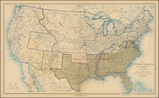
|
||

|

|
|

|
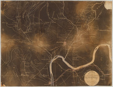
The Siege of Richmond, Depicted from Richmond Itself.
This map, created by Edwin Sheppard in 1862, delineates the strategic battlegrounds of the Chickahominy, alongside the Federal Army's retreat routes towards the James River, amidst the broader context of the Siege of Richmond, Virginia, during the American Civil War. It encompasses elements such as railroads, turnpikes, roads, battlefields, court houses, churches, residences, and notable routes, including Stuart's maneuver from near Kilby's Station through several pivotal points back to Confederate lines.
The Siege of Richmond was a critical episode in the American Civil War, marking a period of intense military and strategic significance. As the capital of the Confederacy, Richmond's defense, and the Union's attempts to capture it were central to the war's outcome. This map's creation in 1862 situates it within a critical juncture of this prolonged engagement, providing contemporary insights into the geographical and logistical complexities faced by both Confederate and Union forces. The detailed depiction of routes, including that of J.E.B. Stuart's cavalry, and the identification of key locations such as battlefields and infrastructure, reflect the tactical considerations pivotal to the era's military operations.
Edwin Sheppard's work in compiling this map from "the most reliable information to be obtained" offers an invaluable resource for understanding the terrain, troop movements, and logistical challenges of the Chickahominy engagements and the broader campaign against Richmond.