|
||

|

|
|

|
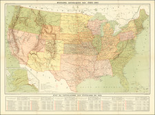
This map depicts the United States at the outset of the Civil War as of June 30, 1861, illustrating the boundaries of the Union and Confederate geographical divisions and departments. The map employs color coding to differentiate between Union and Confederate territories, showing strategic locations and military boundaries relevant to the period. The Western United States is labeled with broad regional names, while more detailed divisions are present in the Eastern United States. Key areas of military significance, such as the Trans-Mississippi and various departmental boundaries, are clearly marked.
This map is a plate from the Atlas to Accompany the Official Records of the Union and Confederate Armies, 1861-1865, a comprehensive collection of maps, illustrations, and documents compiled to provide detailed records of military operations during the Civil War. The atlas was published between 1891 and 1895.