|
||

|

|
|

|
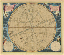
Interesting set of diagrams depicting the basic ways in which the globe and the solar system are projected. The image illustrates the basic methods of modeling the equator, the two Tropics, the Poles, the horizon, and other features of a sphere. Includes decorative armillary spheres and globes in the corners.
The work acts as an instructive image to cartographers and artists as to the ways in which a globe can be properly portrayed. The text on the left-hand side describes the various symbols that may be made use of in imaging a globe. The text on the right side describes the various celestial bodies and points of interest in drawing these maps. All text on this image is in Latin. Overall, this is an intriguing and instructive work from the 18th century.
This plate originally appeared in Doppelmayr's Atlas Coelestis, in quo mundus spectabilis. . ., a treatise on 18th-century astronomical knowledge.
![[ Triangulum ]](https://storage.googleapis.com/raremaps/img/small/88313.jpg)