


|
||

|

|
|

|
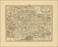
Fine old color example of Hugo Allard's scarce map of the Duchy of Cleves.
Centered on an area between the Rhine River and the Maas or Moselle River the Duchy of Cleves was part of the Holy Roman Empire, between the Prince-Bishopric of Münster in the east and the Duchy of Brabant in the west.
The Duchy included the capital of Cleves and other larger towns in the region including Wesel, Kalkar, Xanten, Emmerich, Rees and Duisburg.
Hugo (or Huych) Allard (or Allardt) (1627–1684 or '91) was a draughtsman, engraver, and painter during the Dutch Golden Age of cartography. Based in Tournai and Amsterdam, he was the founder of a prominent family of Dutch mapmakers, publishers, and print sellers. Allard set up his cartography business around 1645, and his first works were mostly reissues of earlier maps. Although not as prominent as the Blaeu family or Henricus Hondius and Jan Janssonius, Hugo Allard’s work, from about 1640 to 1680, is considered to be just as fine in quality. His output was relatively small, and his maps were mostly published as loose, separate issues, but they were well-designed and finely engraved. After Allard’s death, he left his business to his son, Carel. There is some confusion about when he died; some sources state 1684, others say 1691.
![(Mainz, Würzburg and Sion) Moguntia, Germaniae Metropolis, ad Rheni ripas Urbs Celeberrima, mercatorum frequentia . . . [and] Herbipolis Comuiter Wirtzburg Orientalis Franciae Metropolis [and] Sedunum, primaria & Metropolitica Valesiae urbs . . .](https://storage.googleapis.com/raremaps/img/small/55078mp2.jpg)
![[ Cologne ] Colonia Agrippina](https://storage.googleapis.com/raremaps/img/small/96137.jpg)
![(France, Belgium, and Holland) Tabula Moderna Francie [Modern Map of France]](https://storage.googleapis.com/raremaps/img/small/101885.jpg)
![[Composite Lafreri-style Atlas of Battle Plans and Fortifications]](https://storage.googleapis.com/raremaps/img/small/92702.jpg)