|
||

|

|
|

|
Stock# 87304
Description
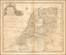
A nice example of Valk and Shenk's original antique map of the German-Dutch border in the vincinity of Nijmegen and Duisburg. This fine map was published in Amsterdam at the end of the 17th century.
The map follows the course of the Rhine as passes from Germany to the Netherlands. In the left of the map, we also see the course of the west of the map. Cities named on the map include Arnhem, Duisburg, Nijmegen, and Essen.
This map shows a plethora of detail. Canals, cities, towns, roads, rivers, forests, and more are all indicated.
Condition Description
Original hand-color in outline.
![[ Enkhuizen ] Nieuwe Afteekening Van Alle De Banken, Canaalen, Tonnen en Dieptens. Geleegen voor de Stad Enkhuysen inde Zuyder Zee . . . .](https://storage.googleapis.com/raremaps/img/small/104258.jpg)
![[Holy Roman Empire] A Newe Mape of Germany Newly Augmented by Iohn Speed Ano Dom: 1626](https://storage.googleapis.com/raremaps/img/small/67323.jpg)