|
||

|

|
|

|
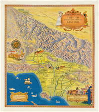
Scarce Early State!
One of the great decorative maps of Southern California, published in the 1950s.
Extends from Malibu Beach, Topanga Canyon and Mission San Frenando to Ensenada, centered on San Juan Capistrano in the west. Death Valley, Las Vegas, Needles, Parker Dam and the Ssalton Sea appear on the Horizon. A remarkable tourist/characture map, showing the points of interest in Southern California and illustrated with decorative scenes of California's history and pre-history (the La Brea Tar Pits!). A lively and highly artistic view of Southern California!
Rarity
The map was reissued a number of times, often with significant changes, between 1946 and 1965, with editions dated 1946, 1950, 1952, 1953, 1954, 1957, 1958, 1950, 1961, 1963 and 1965 known to exist.
![[Southern California Views] Delightful Southern California, The Land of Sunshine and Bloom](https://storage.googleapis.com/raremaps/img/small/74862.jpg)