|
||

|

|
|

|
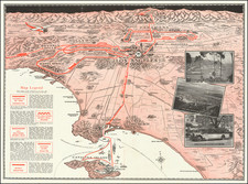
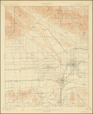
Attractive vintage maps of Los Angeles, with one map showing a detailed street map of Los Angeles, Santa Monica, Hollywood, and the surrounding areas. The second map, printed on the verso of the first, shows Greater Los Angeles, stretching past San Bernardino and deep into Riverside County. These maps were prepared for the Clason Map Company by the Security Trust & Savings Bank of Los Angeles.
The street map of Los Angeles is highly detailed, with all streets and roads named, and railroads shown. An index of hundreds of streets in Beverly Hills, Culver City, and Los Angeles is provided. The complicated boundaries of the city limits are shown in green and major arteries are depicted in red. Branches of the Security Trust & Savings Bank are marked with a red star.
The map on the verso, of Greater Los Angeles, is equally detailed. The map shows paved and unpaved roads, distances from Los Angeles, and other details. The disconnected nature between each of the cities shown is remarkable now that this entire area has been conurbanized. An inset map shows Palm Springs.
![Beverly Hills: il quartiere dei divi e delle stelle, alle porte di Hollywood [Beverly Hills: The Neighborhood of the Divas and the Stars, at Hollywood's Door]](https://storage.googleapis.com/raremaps/img/small/89639.jpg)