


|
||

|

|
|

|
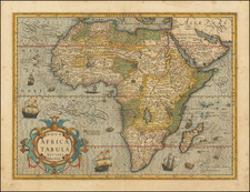
Decorative and detailed map of Africa, published by Guillaume De L'Isle in Paris. The map is attractively laid out, with detail extending into Europe, the Arabian peninsula, India, and Brazil.
The map exhibits the most up-to-date knowledge of Europeans by the middle of the 18th century. The cartography along the coasts is relatively accurate, but the interior is still largely mapped using myth and conjecture.
Numerous Indian Ocean islands are shown, some of which are fictional. The central great lakes of the Rift Valley are hinted at in the area referred to as "Cafrerie". An attempt at demarcating political boundaries is shown.
The map includes a large decorative cartouche as well as a second decorative notice describing the spacing of the lines of longitude used.
Philippe Buache (1700-1773) was one of the most famous French geographers of the eighteenth century. Buache was married to the daughter of the eminent Guillaume Delisle and worked with his father-in-law, carrying on the business after Guillaume died. Buache gained the title geographe du roi in 1729 and was elected to the Academie des Sciences in the same year. Buache was a pioneering theoretical geographer, especially as regards contour lines and watersheds. He is best known for his works such as Considérations géographiques et physiques sur les découvertes nouvelles dans la grande mer (Paris, 1754).
![[Juba / South Sudan / White Nile] Sketch Map of Juba-Torit-Nimuli District](https://storage.googleapis.com/raremaps/img/small/92559.jpg)
![[ Atlantic Ocean / Triangular Trade / Negroland ]](https://storage.googleapis.com/raremaps/img/small/65187.jpg)
![[ First Modern Map of Southern Africa ] Tabula Moderna Secunde Porcionis Aphricae](https://storage.googleapis.com/raremaps/img/small/66800.jpg)

![[ Air Travel Routes in Africa ] Ministre de l'air regie Air Afrique](https://storage.googleapis.com/raremaps/img/small/89402.jpg)