|
||

|

|
|

|
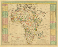
The First Modern Map of Southern Africa
Striking example of renowned mapmaker Martin Waldseemüller's modern map of the southern half of Africa. It was included in the first separate collection of modern maps and made up part of the influential 1513 Strasbourg edition of Ptolemy’s Geographia.
This is the first printed modern map of the region, departing from the traditional Ptolemaic understanding of Africa. The map depicts the area from the equator to the Cape of Good Hope, together with most of Madagascar.
Martin Waldseemuller's 1513 map of South Africa offers an intriguing glimpse into the early days of European exploration and cartography. Waldseemuller, a German cartographer, worked in Saint-Dié-des-Vosges, a significant center for map-making in the 16th century. His best known work, "Universalis Cosmographia," introduced the term "America" to the world.
The 1513 map of South Africa showcases a balance of accuracy and speculation, characteristic of the era. The map's focus is primarily coastal, aligning with the maritime interests of European explorers, with only scant detail on the continent's interior, reflecting the limited understanding of these regions during the early 16th century.
For creating this map, Waldseemuller relied heavily on the voyage accounts of Portuguese explorers Bartolomeu Dias and Vasco da Gama. Dias was the first European known to have navigated around Africa's southern tip, the Cape of Good Hope, in 1488, confirming that the Atlantic and Indian Oceans were linked. Subsequently, da Gama's successful circumnavigation of Africa paved the way for direct maritime trade between Europe and India.
While the map accurately represents major coastal points, the inland areas are populated with somewhat imaginative depictions of animals, such as elephants and lions. These were likely inspired by explorers' accounts and represent Waldseemuller's efforts to bring life to the then largely unknown interior.
Human settlements are sparsely indicated, with one notable inclusion being the symbolic representation of the Kingdom of Prester John, a Christian realm Europeans believed existed in Africa.
The map reflects a detailed understanding of the coastline accumulated though the work of Portuguese explorers, culminating in Vasco da Gama's circumnavigation of Africa in 1497-99. Numerous toponyms radiate inland.
The interior, by contrast, is largely empty; indeed, a note on the map explains that it remained unknown, or incognita, to the ancients, as it did to sixteenth-century Europeans. The exception is the classical depiction of the source of the Nile at Mono Lune, the Mountains of the Moon. This reflects Waldseemüller's dependence on sailor accounts, in particular those of the Portuguese—few Europeans had traveled beyond the coastal regions and would not do so until the mid-nineteenth century.
Europeans had been interested in the source of the Nile for millennia. Ptolemy, in his second-century Geographia, postulated that the source lay near the Mountains of the Moon, where water flows into two large lakes at the same latitude. This theory came from Diogenes, who supposedly saw the mountains ca. 110 CE.
Early editions of Ptolemy and the Ptolemaic mapping of Africa
Ptolemy’s ideas, however, had been absent from western European intellectual history for roughly a thousand years, although Arab scholars interacted with his ideas from the ninth century onward. In 1295, a Greek monk found a copy of Ptolemy in Constantinople; the emperor ordered a copy made and the Greek text began to circulate in eastern Europe. In 1393, a Byzantine diplomat brought a copy of the Geographia to Italy, where it was translated into Latin in 1406 and called the Cosmographia. The manuscript maps were first recorded in 1415. These manuscripts, of which there are over eighty extant today, are the descendants of Ptolemy’s work and a now-lost atlas consisting of a world map and 26 regional maps.
When Ptolemy’s work was re-introduced to Western scholarship, it proved radically influential for the understanding and appearance of maps. Ptolemy employs the concept of a graticule, uses latitude and longitude, and orients his maps to the north—concepts we take for granted today. The Geographia’s text is concerned with three main issues with regard to geography: the size and shape of the earth; map projection, i.e. how to represent the world’s curve proportionally on a plane surface; and the corruption of spatial data as it transfers from source to source. The text also contains instructions as to how to map the world on a globe or a plane surface, complete with the only set of geographic coordinates (8000 toponyms, 6400 with coordinates) to survive from the classical world.
Some of the most important early printed maps were in editions of Ptolemy’s Geographia (Cosmographia); indeed, 31 editions of the work with the maps were printed before 1600. The text was first published in 1475 in Venice without the maps. An edition with the maps followed in 1477, printed in Bologna. These maps were another first—they were the first copperplate maps, in which an engraver scores copper, which is then inked and pressed. The Bologna edition included 25 of the original 26 regional maps (map XV was missing), as well as the world map.
A second edition with maps appeared in Rome in 1478. The third edition with maps was printed in Florence in 1482, the first to be printed in a vernacular language, Italian. It included 31 copperplate engraved maps, making it the first to augment the traditional 27 Ptolemaic maps with tabulae novellae, or modern maps. The modern maps included maps of Italy, Spain, and France. The next edition to include maps was the 1482 Ulm edition; this was the first atlas to be printed north of the Alps, as well as the first to use woodcut, not copperplate, printing.
In Ptolemaic geography, Africa is only shown from the Tropic of Capricorn north. Eastern Africa is attached to Asia via a massive land bridge, making the Indian Ocean an enclosed sea. In the original set of 27 maps of the Ptolemaic Geographia, there are four maps focused on Africa. Three of these maps show portions of Northern Africa as it borders the Mediterranean Sea; they run from west to east. The fourth map shows all that Ptolemy knew of Africa, the Mediterranean coast, Libya interior, Etiopia Exterior, and Etiopia Sub-Egipto. To the south is Terra Incognita, which was only beginning to be known to Europeans, in outline form, when this map was published at the beginning of the sixteenth century.
The 1513 Strasbourg edition of Ptolemy’s Geographia
This map appeared in Waldseemüller’s 1513 edition of Ptolemy’s influential Geographia, printed by Waldsemüller’s friend and collaborator Johann Schott. It is likely that Waldseemüller, along with the scholar Matthias Ringmann, started working on the project as early as 1505, but the death of their patron, René II, in 1508 resulted in the closure of their press at St. Dié. Additionally, Ringmann died in 1511. Schott and Waldseemüller finally finished the project in 1513, publishing it with Schott in Strasbourg.
The 1513 edition marked an important shift in the history of cartography because it was the first printing of Ptolemy to incorporate a large set of tabulae novellae, or modern maps, that were separated from the ancient, or Ptolemaic, version of geography. The 27 original Ptolemaic maps were accompanied by 20 modern maps, of which this is one. All of its maps were printed from beautifully carved woodblocks made of pear wood. This edition of the Geographia was also the first to be organized so as to separate the ancient from the modern maps, to show how knowledge had changed since Ptolemy’s time fourteen centuries earlier.
Portuguese exploration of the African coast
As compared to traditional Ptolemaic maps of Africa, this modern map of South Africa, accompanied in the 1513 edition by a corresponding map of the northern part of the continent, shows Africa south to, and around, the Cape of Good Hope. This knowledge came to Waldseemüller via maritime and geographic networks that stretched from East Asia to his workshop in St. Dié and, later, Strasbourg.
Most of these reports came from Portuguese expeditions. By the end of the fourteenth century, the Mongol Empire was breaking up, meaning that the land-based trade routes to Asia were no longer as stable and safe as they had been. The Portuguese were relatively sheltered, thanks to their geography, from the ravages of the Black Death that was decimating Europe in the fifteenth century. Additionally, their prolonged historical encounter with Islam lent them knowledge of sailing and mathematical instruments and techniques that enabled their fleet to take on the rough waters of the open Atlantic.
The Portuguese pushed southward along the shores of Sierra Leone, setting up trade posts on the coast. They traded for a variety of goods including, unfortunately, human beings. In 1471, Fernão do Pó reached the Gulf of Guinea. In 1482, Diogo Cão found the Congo River. Five years later, Bartolmeu Dias pushed farther south, to the Great Fish River in what is now South Africa. Five years after that, in 1497, Vasco da Gama sailed the first fleet to round the Cape of Good Hope, renamed from Dias’ Cape of Storms. He then sailed north along the coast of East Africa, reaching Calicut (Kozhikode) on the east coast of India. Thereafter, vessels and fleets frequently sailed the route to the East Indies, eventually stopping en route in Brazil and in factories that stretched from West Africa to the Red Sea to the Moluccas.
This map shows a region important to European exploration at a time when Europeans were beginning to know more about the region. It is a mixture of ancient and modern scholarship and was part of the hugely influential 1513 Strasbourg edition of Ptolemy. Waldseemüller was one of the most important cartographers of the fifteenth century and this map is a vital addition to any collector of Africa, Ptolemy, or Waldseemüller.
Martin Waldseemüller (c. 1475-1520) was a sixteenth-century cosmographer best known for his 1507 world map in twelve sheets, the earliest surviving map to include the name “America.” He was an influential mapmaker during his time whose work affected many of his contemporaries and successors. Waldseemüller was born near Freiburg, in what is now southwestern Germany. His family moved to Freiburg proper when he was young and he attended university in the city beginning in 1490.
Waldseemüller gathered information about the New World discoveries and geography from St.-Dié des Vosges in Lorraine, where he was a professor of cosmography under the patronage of René II, Duke of Lorraine. He was a member of an intellectual circle who produced work from the St.-Dié Press. However, the press failed when the Duke died, and Waldseemüller moved to Strasbourg.
He is best known for the 1507 map and another world projection, the Carta Marina published in 1516. He also published an edition of Ptolemy in 1513, in collaboration with Johann Schott, a friend from Freiburg and St.-Dié. Besides his innovative use of the toponym “America”, Waldseemüller was the first to create such a large printed world map, the author of the earliest known printed globe gores, the first to create a published collection of modern maps, and one of the first to create maps from ground measurements. He was knowledgeable in surveying methods and designed a quadrant and other instruments. He returned to St.-Dié late in life as canon, although he continued to return to Strasbourg for work and for carnival. He died in St.-Dié in 1520.
Waldseemuller is generally credited with having named the continent of America, based upon the then current belief that Amerigo Vespucci had been the first modern explorer to reach the continent of America in 1497, during the first of four expeditions to America which were then credited to Vespucci between 1497 and 1504. The report which described the 1497 expedition is now generally believed to be a forgery. Later in his career, Waldseemüller elected not to use the toponym for the continents, preferring to leave them unnamed. However, the name had been taken up by his contemporaries, in large part due to the influential nature of Waldseemüller’s earlier works.
![[ First Modern Map of Southern Africa ] Tabula Moderna Secunde Porcionis Aphricae](https://storage.googleapis.com/raremaps/img/small/66800.jpg)
![[ West Africa ] A Chart of Guinea Describing the Seacoast from Cape de Verde to Cape Bona Esperanca](https://storage.googleapis.com/raremaps/img/small/99962.jpg)
![[ Ancient World ] Christianographie](https://storage.googleapis.com/raremaps/img/small/80305.jpg)