|
||

|

|
|

|
Stock# 76176
Description
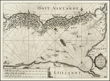
The right sheet of a two-sheet map showing the southeastern part of Finland as well as part of the Baltic states and St. Petersburg. Estonia and Livonia (Latvia) are marked in the south. The southern portion of Lapland is visible at the top of the map. The extensive Lake Lagoda is visible in the east, on the far side of St. Petersburg.
This sheet contains a scale bar as well as latitude and longitude markings. The detail is attractive and extensive on this map, with many cities named and forests, lakes, islands, rivers, and other geographical reference points shown.
Condition Description
Attractively hand-colored example.
![Pomeraniae, Wandalicae Regionis Typ [with] Livoniae Nova Descriptio [with] Ducatus Oswieczensis, et Zatoriensis, Descriptio](https://storage.googleapis.com/raremaps/img/small/100719.jpg)
![[Latvia & Estonia] Livonia](https://storage.googleapis.com/raremaps/img/small/69198.jpg)