|
||

|

|
|

|
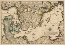
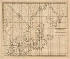
Herman Moll's map, "Russia or Moscovy with its Acquistions &c. in Sweden," is a meticulously constructed visual display of Eastern Europe, representing Russia's increased influence in the Baltic region in the early 18th century. Covering territories from Swedish Finland to Rus-Lapland and Rus-Finland, Moll's map accurately showcases the varied topography and intricate political boundaries of the time.
The map has an interesting feature: a note detailing a proposed communication link between the Volga and Don Rivers. During the first half of the 18th century, Russia was experiencing a phase of rapid infrastructural growth and advancement. It was during this time that the idea of connecting the Volga and Don Rivers through a canal was conceived. This canal would provide a more direct trade route between the Caspian Sea and the Black Sea, bolstering Russia's economic and strategic position.
Moll's map clearly showcases the anticipated course of this canal, indicating the significant role it would play in shaping Russia's political and economic future. This ambitious project was a reflection of Russia's growing desire to assert its dominance in the region, particularly in the sphere of trade and commerce.
The map also provides an interesting snapshot of the various anglicized names in the Baltic region and White Russia, hinting at the influences and cultural intermingling taking place at the time. Moreover, Moll's map credits Russian maps for the details provided in Southern Russia, emphasizing the sharing and exchange of geographical information and knowledge between different regions and cultures.
It offers detailed notes on St. Petersburg, reflecting its rising significance in Russia and Europe. At the time, the city was transforming into a major hub for trade and commerce, as well as a cultural capital. Moll's emphasis on the increasing size of Russia is also evident in the map, capturing the growth and expansion that was a crucial part of the country's historical trajectory.
Herman Moll (c. 1654-1732) was one of the most important London mapmakers in the first half of the eighteenth century. Moll was probably born in Bremen, Germany, around 1654. He moved to London to escape the Scanian Wars. His earliest work was as an engraver for Moses Pitt on the production of the English Atlas, a failed work which landed Pitt in debtor's prison. Moll also engraved for Sir Jonas Moore, Grenville Collins, John Adair, and the Seller & Price firm. He published his first original maps in the early 1680s and had set up his own shop by the 1690s.
Moll's work quickly helped him become a member of a group which congregated at Jonathan's Coffee House at Number 20 Exchange Alley, Cornhill, where speculators met to trade stock. Moll's circle included the scientist Robert Hooke, the archaeologist William Stuckley, the authors Jonathan Swift and Daniel Defoe, and the intellectually-gifted pirates William Dampier, Woodes Rogers and William Hacke. From these contacts, Moll gained a great deal of privileged information that was included in his maps.
Over the course of his career, he published dozens of geographies, atlases, and histories, not to mention numerous sheet maps. His most famous works are Atlas Geographus, a monthly magazine that ran from 1708 to 1717, and The World Described (1715-54). He also frequently made maps for books, including those of Dampier’s publications and Swift’s Gulliver’s Travels. Moll died in 1732. It is likely that his plates passed to another contemporary, Thomas Bowles, after this death.
![[Ukraine, Russia] Asiae II Tab:](https://storage.googleapis.com/raremaps/img/small/89178.jpg)