|
||

|

|
|

|
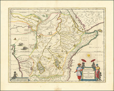
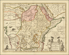
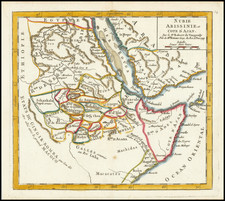
Sanuto's important map of East Africa and the edge of the Arabian Peninsula showing the meeting point between the Red Sea and the Gulf of Aden. This highly decorative map is embellished with numerous sailing ships and stippling in the ocean. This work is from one of the most important 16th-century texts on Africa, Sanuto's uncommon Geografia.
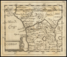
The map shows copious detail, with many named regions, rivers, and mountain ranges. The Nile River is shown branching into its White and Blue headwaters. A large forest appears along the Eritrean coastline. Numerous cities, most apparently mythical, are named.
In all, a very decorative and important early map of the region.
What would have been one of the foremost Renaissance works on world geography had it been completed (Skelton, 1964), Sanuto's premature death instead led his Geografia to become a rare but important work on African geography. Having planned to publish his work in four parts, with a part on each of the known continents, Sanuto only ever managed to write his first part. This Primera Parte focused on Africa (following a scholarly and often-referenced discussion of the longitude question and Cabot's role in solving it) and included information from various sources as well as Lafreri School-style maps.
Despite the work's incomplete nature, it remained one of the most referenced contemporary texts on Africa for at least one hundred years, being cited in northern European works as well as Coronelli's 1691 Atlante Veneto. However, its highly academic introduction dissuaded a popular readership, which limited its circulation and it was never translated or reprinted, with only the 1588 edition ever having been created.
Sanuto's maps of Africa compile from many sources and display an acute critical sense. First of all, his trapezoidal projections chosen, echoing Donnus Nicolaus Germanus's Ptolomeic atlases from a hundred years earlier, were uncommon at the time. His maps further show innovation in the reconciliation of a well-known coastline with interior topographical information that draws from several thousand years of at-times conflicting literary knowledge.
The main rival in detailed 16th-century mapping of Africa was Gastaldi's 1564 great map of Africa. In comparing the two, scholars argue that Sanuto was more faithful to his sources, and provided fewer place names but with greater accuracy.
Sanuto's maps are not only academic achievements but also beautiful engravings typical of late Lafreri School cartography.
Livio Sanuto (c.1520-1576), was a Venetian cosmographer, mathematician and maker of terrestrial globes and also belonged to the prestigious Lafreri school of engravers, whose output signalled the transition between the maps of Ptolemy and the maps of Mercator and Ortelius.
Livio and his brother Giulio planned a massive, comprehensive atlas to include maps and descriptions of the whole world, which he believed would be more accurate than any previously published. Unfortunately, he died in 1576 having only completed twelve maps of Africa. The twelve maps were eventually published in 1588 by Livio's brother Giulio, under the title "Geografia Di M. Livio Sanuto..." .