|
||

|

|
|

|
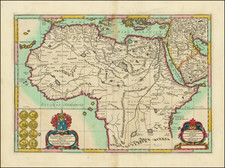
Nice example of Sanson's 1655 double-page engraved map of the Tunisian and Libyan coast of North Africa. Sanson's map also shows the islands of Malta, Limosa, Lampedusa, and the southernmost coast of Sicily.
The is a tangible testament to the seafaring explorations and geographical understandings of the 17th-century European cartographers. It presents a comprehensive depiction of a substantial region of North Africa, predominantly the Barbary Coast, with an emphasis on the Kingdoms of Tunis and Tripoli.
Despite the inherent limitations of 17th-century cartography, this particular map displays remarkable accuracy. The coastlines are delineated with precision and clarity, highlighting significant bays, promontories, and harbors. Equally, the cartographer represents the Kingdoms of Tunis and Tripoli as individual entities, distinct from each other yet part of the larger Barbary Coast region, extending into the mountainous regions north of the Sahara Desert.
The Barbary Coast, as the Europeans referred to it, was the term used for the North African territories under the rule of the Ottoman Empire, mainly encompassing modern-day Morocco, Algeria, Tunisia, and Libya. During the 17th-century, it was a region of pivotal maritime significance and a center of diplomatic and commercial interactions between the Europeans and the Ottomans. The Kingdoms of Tunis and Tripoli were vassal states under the Ottoman suzerainty.
Tunis and Tripoli were notorious for corsair activity during this period. Corsairs were privateers or pirates who operated along the Barbary Coast, under the tacit approval of the local rulers. They posed a significant threat to European maritime commerce, leading to several conflicts known as the Barbary Wars. This socio-political context provided a compelling motive for the detailed mapping of the region.
Nicholas Sanson (1600-1667) is considered the father of French cartography in its golden age from the mid-seventeenth century to the mid-eighteenth. Over the course of his career he produced over 300 maps; they are known for their clean style and extensive research. Sanson was largely responsible for beginning the shift of cartographic production and excellence from Amsterdam to Paris in the later-seventeenth century.
Sanson was born in Abbeville in Picardy. He made his first map at age twenty, a wall map of ancient Gaul. Upon moving to Paris, he gained the attention of Cardinal Richelieu, who made an introduction of Sanson to King Louis XIII. This led to Sanson's tutoring of the king and the granting of the title ingenieur-geographe du roi.
His success can be chalked up to his geographic and research skills, but also to his partnership with Pierre Mariette. Early in his career, Sanson worked primarily with the publisher Melchior Tavernier. Mariette purchased Tavernier’s business in 1644. Sanson worked with Mariette until 1657, when the latter died. Mariette’s son, also Pierre, helped to publish the Cartes générales de toutes les parties du monde (1658), Sanson' atlas and the first French world atlas.
![[Moroccan Coast -- Agadir, Essaouira, Safi] Afbeeldinge nae't leven der Zeecusten van Barbarien, van de C. Cantin zuijdwaert tot verbij de C. de Geer, mitsgaders de gelegentheijt van't eijlant Mogodor, alles op zijne rechte Streckinge en hoochte gestelt](https://storage.googleapis.com/raremaps/img/small/62163.jpg)
![[Capture of Mahdia in 1550] Vera urbis Africae descriptio, p Illust. D. Viceregem Sicilae, & Antonium Doriam, Caroli. v. Imper inuictiss. Duces iam expugnatae. 1550](https://storage.googleapis.com/raremaps/img/small/78592.jpg)