


|
||

|

|
|

|
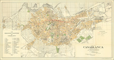
Stock# 105239
Description
French Modernist Design Map of Rabat.
This is a detailed street map of Rabat, Morocco, circa 1930, created by Guy Loutrel and published by Ch. de Massey. The map outlines the city's streets and significant landmarks, providing a comprehensive view of Rabat and its surroundings, including the adjacent town of Salé. The map features a grid system for ease of reference and is stamped by the "Service de Perceptions et Recettes Municipales." The map's text indicates that Guy Loutrel was based near the Théâtre de la Renaissance on Avenue Dar el Makhzen in Rabat and engaged in real estate dealings, capital placements, and had the exclusive monopoly of the main subdivisions of Rabat.
Condition Description
Lithographed folding map. Some annotations in blue and red pencil. Some foxing.
![[ Ethiopia, Sudan & Eritrea ] Nubia and Abysssinia](https://storage.googleapis.com/raremaps/img/small/101736.jpg)
![[ Morocco Coast -- Tangiers to El Beddouza ] Eijgentlijke vertooninge der westcuste van Barbarien, tusschen de Strate van Gibraltar ende de C: de Cantin, zampt aller Reeden Havenen ende Rivieren aldaer gelegen, en hoemen die bequamelijck sal besijlen](https://storage.googleapis.com/raremaps/img/small/62218.jpg)