|
||

|

|
|

|
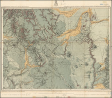
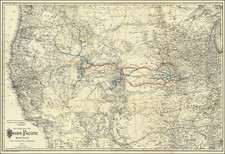
Military and Indian Affairs Map Regarding the Navajo Indian Reservation
Interesting untitled map of the region centered on the Navajo and Hopi Indian Reservations, which was likely the map described in a report to Congress made by the Commissioner of Indian Affairs in 1893.
The map was likely published in conjunction a report of the Commissioner of Indian Affairs dated February 14, 1893, which reports on:
the situation among the Navajo Indians in New Mexico and Arizona, wherein the Commissioner recommended that the plan suggested by General McCook to redistrict the Navajo country into suitable portions and to detail proper officers to thoroughly inspect the entire region, make a contour map of it, and submit a detailed report, so that this Department could be advised as to the practicability of restraining the Navajos within their present reservation and of furnishing irrigation and water of their flocks, with request that the necessary instructions might be given to the honorable Secretary of War to carry out the recommendations therein contained.
The report includes the following note:
On August 1, 1892, this Department had the honor to submit to you a communication from the Commissioner of Indian Affairs relative to the situation among the Navajo Indians in New Mexico and Arizona, wherein he recommended that the plan suggested by Gen. McCook to redistrict the Navajo country . . . t
I now have the honor to transmit copy of a communication of the 20th December last from the honorable Secretary of War, transmitting reports of Lieuts. Brown, Gurovits, and Suplee, U. S. Army, the officers charged with the duty, together with notes and explanatory maps, and also copy of a report of the Commissioner of Indian Affairs of the 10th instant relative to the same. . . .
At the center of the map, a meticulous accounting of a number of government expeditions north of Fort Defiance at the end of the 19th Century is given, including routes for:
- Lt. Suplee
- Lt. Gurovits
- Lt. Brown
The routes note Chee's Store and Chrilee Store.
The San Juan River is shown in the north, with Monument Valley at the north center of the map and Glen Canyon and Horseshoe Bend at the top left.
The map extends south to the area around Gallup and Wingate, New Mexico and southwest to the area southwest of Flagstaff.
The map provides excellent topographical detail, as well as locating small towns, roads, springs, lakes tanks and other details.
![[Battle of Taos] Sketch accompanying Col. Price Despatch](https://storage.googleapis.com/raremaps/img/small/92129.jpg)