


|
||

|

|
|

|
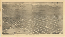
Salt Lake City Map with Early Automotive Advertisements for Vico Oil and Pepp 88 Gasoline
Rare early state of W.E. Farr's map of Salt Lake City, first published in 1925.
The map shows radiating concentric circles centered on the Temple Block and downtown Salt Lake City.
The legend notes Court Location, Street Car Routes and Out Going [Street] Car Numbers.
The map extends west to the Salt Lake Municipal Airport, north to Hot Springs Lake, east to Terrace Park, Fort Douglas and the US Military Reservation and Wasatch Blvd, and south to 45th Street South.
The Salt Lake Municipal Airport was then one of the stops on the Transcontinental Mail Route. The route started in 1920. The first legs of this transcontinental route — from New York to Cleveland with a stop at Bellefonte, Pennsylvania, then from Cleveland to Chicago, with a stop at Bryan, Ohio — opened in 1919. A third leg opened in 1920 from Chicago to Omaha, via Iowa City, and feeder lines were established from St. Louis and Minneapolis to Chicago. The last transcontinental segment — from Omaha to San Francisco, via North Platte, Nebraska; Cheyenne, Rawlins, and Rock Springs in Wyoming; Salt Lake City, Utah; and Elko and Reno in Nevada — opened on September 8, 1920.
Includes advertising for Sugar House Lumber & Hardware at the bottom left.
![Birds-Eye View of Salt Lake City, From the North, Looking South-East, Utah, 1875. [Cabinet card version.]](https://storage.googleapis.com/raremaps/img/small/92362.jpg)
![[ Idaho Below Montana ] Verein-Staaten am Stillen Ocean… [inset of San Francisco Bay] [Unusual Idaho & California configurations]](https://storage.googleapis.com/raremaps/img/small/99297.jpg)