


|
||

|

|
|

|
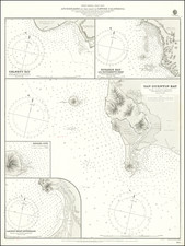
Finely detailed chart of Pichilinque Harbor, just to the north of La Paz, published by the British Admiralty.
The chart shows the salt beds at the southern tip of the San Juan Nepomezeino Island, along with the U.S. Government Coal Depot
Pichilinque, derived from a Guaycura name, was originally a favored anchorage in the Bay of La Paz. This anchorage was used by the U. S. Navy for a base of operations against the west coast of Mexico during the Mexican American War. It later developed into a port. Two ferry services operate from the port of Pichilingue, connecting the Baja California peninsula to the mainland at Mazatlán and Topolobampo, near Los Mochis.
At the time this chart was published, the island of San Juan Nepomezeino had not yet been connected to the mainland, although the depth in the channel separating the the island from the mainland was already very shallow.
The British Admiralty has produced nautical charts since 1795 under the auspices of the United Kingdom Hydrographic Office (HO). Its main task was to provide the Royal Navy with navigational products and service, but since 1821 it has also sold charts to the public.
In 1795, King George III appointed Alexander Dalrymple, a pedantic geographer, to consolidate, catalogue, and improve the Royal Navy’s charts. He produced the first chart as the Hydrographer to the Admiralty in 1802. Dalrymple, known for his sticky personality, served until his death in 1808, when he was succeeded by Captain Thomas Hurd. The HO has been run by naval officers ever since.
Hurd professionalized the office and increased its efficiency. He was succeeded by the Arctic explorer Captain William Parry in 1823. By 1825, the HO was offering over seven hundred charts and views for sale. Under Parry, the HO also began to participate in exploratory expeditions. The first was a joint French-Spanish-British trip to the South Atlantic, a voyage organized in part by the Royal Society of London.
In 1829, Rear-Admiral Sir Francis Beaufort was appointed Hydrographer Royal. Under his management, the HO introduced the wind force scale named for him, as well as began issuing official tide tables (1833). It was under Beaufort that HMS Beagle completed several surveying missions, including its most famous voyage commanded by Captain FitzRoy with Charles Darwin onboard. When Beaufort retired in 1855, the HO had nearly two thousand charts in its catalog.
Later in the nineteenth century, the HO supported the Challenger expedition, which is credited with helping to found the discipline of oceanography. The HO participated in the International Meridian Conference which decided on the Greenwich Meridian as the Prime Meridian. Regulation and standardization of oceanic and navigational measures continued into the twentieth century, with the HO participating at the first International Hydrographic Organization meeting in 1921.
During World War II, the HO chart making facility moved to Taunton, the first purpose-built building it ever inhabited. In 1953, the first purpose-built survey ship went to sea, the HMS Vidal. Today, there is an entire class of survey vessels that make up the Royal Navy’s Hydrographic Squadron. The HO began to computerize their charts in the late 1960s and early 1970s. In 1968, the compilation staff also came to Taunton, and the HO continues to work from there today.
![[La Paz / Estero de Agiabampo / Santa Maria Cove] Ports of the Gulf of California](https://storage.googleapis.com/raremaps/img/small/73352.jpg)

![[ The First SCORE Off-Road Desert Race Course Maps ] Mickey Thompson's SCORE Parker 400 -- Arizona Side and California Side](https://storage.googleapis.com/raremaps/img/small/97070.jpg)
![[Baja California--Cabo San Lucas] Amer. Sep. No. 58 Partie De La Vielle Californie [and] Amer. Sep. No. 63 Partie De La Vielle Californie](https://storage.googleapis.com/raremaps/img/small/100744.jpg)