|
||

|

|
|

|
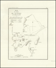
Detailed chart of the anchorages in the Gulf of California, including those on the eastern shores of Baja California.
Much of the information comes from Henry Kellett's important 1845 hydrographical survey for the Royal Navy, undertaken on HMS Herald for the Royal Navy. The primary objective of that survey was to cover the coast of North America from Guayaquil to Vancouver.
The map includes the following plans, clockwise from the upper-left corner:
- Pulpito Anchorage Surveyed by Captn. H. Kellett, R.N., C.B. 1849.
- Puerto Refugio From the United States Government Chart of 1878.
- Amortajada Bay Surveyed by Captn. H. Kellett, R.N., C.B. 1849.
- San Lorenzo Channel From the United States Government Chart of 1904.
- Puerto Santa Rosalia Approaches From the United States Government Chart of 1915.
- Santa Teresa and San Francisquito Bays From the United States Government Chart of 1878.
- Salinas Bay Surveyed by Captn. H. Kellett, R.N., C.B. 1849.
- Mangles Anchorage Surveyed by Captn. H. Kellett, R.N., C.B. 1849.
The British Admiralty has produced nautical charts since 1795 under the auspices of the United Kingdom Hydrographic Office (HO). Its main task was to provide the Royal Navy with navigational products and service, but since 1821 it has also sold charts to the public.
In 1795, King George III appointed Alexander Dalrymple, a pedantic geographer, to consolidate, catalogue, and improve the Royal Navy’s charts. He produced the first chart as the Hydrographer to the Admiralty in 1802. Dalrymple, known for his sticky personality, served until his death in 1808, when he was succeeded by Captain Thomas Hurd. The HO has been run by naval officers ever since.
Hurd professionalized the office and increased its efficiency. He was succeeded by the Arctic explorer Captain William Parry in 1823. By 1825, the HO was offering over seven hundred charts and views for sale. Under Parry, the HO also began to participate in exploratory expeditions. The first was a joint French-Spanish-British trip to the South Atlantic, a voyage organized in part by the Royal Society of London.
In 1829, Rear-Admiral Sir Francis Beaufort was appointed Hydrographer Royal. Under his management, the HO introduced the wind force scale named for him, as well as began issuing official tide tables (1833). It was under Beaufort that HMS Beagle completed several surveying missions, including its most famous voyage commanded by Captain FitzRoy with Charles Darwin onboard. When Beaufort retired in 1855, the HO had nearly two thousand charts in its catalog.
Later in the nineteenth century, the HO supported the Challenger expedition, which is credited with helping to found the discipline of oceanography. The HO participated in the International Meridian Conference which decided on the Greenwich Meridian as the Prime Meridian. Regulation and standardization of oceanic and navigational measures continued into the twentieth century, with the HO participating at the first International Hydrographic Organization meeting in 1921.
During World War II, the HO chart making facility moved to Taunton, the first purpose-built building it ever inhabited. In 1953, the first purpose-built survey ship went to sea, the HMS Vidal. Today, there is an entire class of survey vessels that make up the Royal Navy’s Hydrographic Squadron. The HO began to computerize their charts in the late 1960s and early 1970s. In 1968, the compilation staff also came to Taunton, and the HO continues to work from there today.
![[Chiapas] Carta Postal de la Republica Mexicana Estado de Chiapas . . . 1934](https://storage.googleapis.com/raremaps/img/small/55436.jpg)
![(Mexico City) Cartilla Historica de la Ciudad de Mexico [with map:] Plano de la Ciudad de Tenochtitlan en el año de 1519](https://storage.googleapis.com/raremaps/img/small/104672.jpg)