|
||

|

|
|

|
Stock# 71772
Description
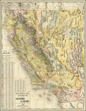
Rare Early Geological Map of the Humboldt Mining Region
The map depicts a section of Humboldt County Nevada, east of the Humboldt River and Lassen Meadow, from just north of Mill City in the north to just south of the Humboldt Range.
The Emigrant road shown on the map more or less approximates the modern I-95 through the region.
Guillemin-Tarayre's map is part of a rare set of scientific works published by the French government. The map illustrated a section that relates to geology and mining in California and Nevada. In 1864, as a result of a French military expedition to Mexico, the Commission Scientifique du Mexique was established. At the time, mining in California and Nevada were the focal point of a great deal of interest in Europe.
![(The Father of Modern Geology) Charles Lyell Esq.r F.R.S. F.G.S. [with facsimile signature]](https://storage.googleapis.com/raremaps/img/small/86594.jpg)