


|
||

|

|
|

|
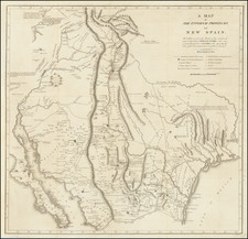
Nice example of the rare 1870 edition of Leander Ransom's map of California and Nevada, published in San Francisco by Warren Holt.
One of the most interesting and detailed maps of the region, called by Wheat "a Nevada map of first importance." (Wheat 1071, illustrated at p. 77). The map was first issued in 1862 (copyrighted 1861). In the first several editions of the map, the Nevada-Utah borders is on the 116th meridian. In one of the 1863 editions, the border is moved to the 115th Meridian. With this edition, the boundary now extends to the 114th meridian, further reducing the size of Utah.
Rumsey notes that this is a superb map, full of interesting and exotic information. The treatment of the Land and Mining Districts in Nevada and California is remarkable, as are the depiction of the roads in Nevada to the mining districts. The map is also one of the earliest maps of California printed in San Francisco.
In this 1870 edition, A.J. Doolittle is no longer listed as one of the mapmakers and the title has been revised to reference the Silver Mining Districts of Nevada Territory. The line of the Southern Pacific Railroad is now shown, extending from Ft. Mohave to San Francisco.
One of the best large format maps of California from the period.
Rarity
The 1870 edition of the map is very rare. This is the first example we have ever seen.
![[ Cabo San Lucas, Southern Baja ] Delineatio Nova Et Vera Partis Australis Novi Mexici, cum Australi Parte Insulae Californiae Saeculo Priori ab Hispnis Detectae.](https://storage.googleapis.com/raremaps/img/small/95666.jpg)
![Fly to a Holiday on Continental [Golden Jet Souvenir Flight Map]](https://storage.googleapis.com/raremaps/img/small/90328.jpg)