|
||

|

|
|

|
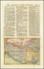
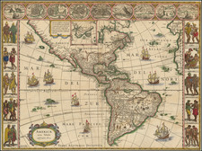
Finely-Drawn Eighteenth-Century Manuscript Map of the Western Hemisphere
Carefully-constructed, single-hemisphere manuscript map of the Americas, signed by Michael Rampf.
Oceans, continents, and cartographic elements such as the equator, tropics, and polar circles are all labeled. Rivers also are included, although they are not named. There are no place names along the shores or inland.
The outlines of the landmasses are made in a recognizable but inexact manner. The toponyms and words, by contrast, written in German, are made in a delicate, scrolling hand. The aesthetic of the map and information it includes suggest that it was a student project, meant to help learn geographic vocabulary and conventions. It seems the student, Michael Rampf, signed his assignment.
North America includes a rough, approximate shape for Alaska and an indeterminate California—it could be an island or a peninsula. The shore is open to the far north and Greenland is connected to the continent via Baffin Bay.
South America is slightly bowed to the east. There is no southern continent, although there is an unfinished coastline east of Tierra del Fuego. There are similar phantom coasts west of South America.
In the Pacific, New Zealand’s coastline is unfinished, suggesting that this map was made before the voyages of James Cook were widely known. Combined with the depiction of Alaska, which suggests that the base map had integrated some of the information from the Bering expeditions of 1725-30 and 1733-43, a likely date of creation is ca. 1760-1770. The paleography is consistent with this date range.
Drawing maps was a common part of the curriculum for students across the world, dating from the later eighteenth century—this is one of the earliest examples of the practice extant. Maps could be made as part of a formal curriculum, or a home education. In the US context, many of the student maps were made by young women, who also embroidered maps. Only a few of these map projects survive, however. This appears to be an assignment set in a Prussian school, which were being institutionalized from 1763, creating one of the earliest free and compulsory education systems in the world.
Rarity
While student maps appear on the market with some frequency, most are from the nineteenth century. This is one of the first hand-drawn student maps we have handled dating from this earlier time period.
![[Portrait] L'Amerique.](https://storage.googleapis.com/raremaps/img/small/79745.jpg)