|
||

|

|
|

|
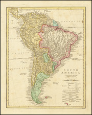
Decorative map of South America, hand colored by countries. Shows cities, mountains, rivers, lakes, islands, etc. Shows the Solomon Islands, the Land seen by Englishmen in 1635 and Davis' Land seen in 1636 in the Pacific and includes a mythical depiction of Terra Australis south of the island of Alvarez and Tristand de Cunha, in the Atlantic. Compass Rose and Title Cartouche. Emanuel Bowen was the Royal Geographer in London for a number of years in the mid-18th Century and was one of the most prolific map publishers of his time.
Emanuel Bowen (1694?-1767) was a British engraver and print seller. He was most well-known for his atlases and county maps. Although he died in poverty, he was widely acknowledged for his expertise and was appointed as mapmaker to both George II of England and Louis XV of France. His business was carried on by his son, Thomas Bowen. He also trained many apprentices, two of whom became prominent mapmakers, Thomas Kitchin and Thomas Jeffreys.
![[ Canary Islands and Madeira Islands ] Isola di Canarie. . [with] Isola Madeira](https://storage.googleapis.com/raremaps/img/small/98646.jpg)